        |
The 1960s - Part 6This series is a little more "then and now"; it focuses on the area between Atlantic and Belmont Avenues and highlights the many changes in that section. |
|||||||||||||||||||||||||||||||||||||||||||||||||||||||||||||||||||||||||

|

|
Georgia and Glenmore Avenues, 1965 and 2015 The view is north up Georgia Avenue from Glenmore, and on the right the huge brick structure is the Piels brewery, which would be torn down in the mid 1970s. That ugly industrial structure on the left was built around 1962; we have a view of what that block looked like in the 1940s below. | |||||||||||||||||||||||||||||||||||||||||||||||||||||||||||||||||||||||

|

|
Georgia and Glenmore Avenues, 1965 and 2015 The camera is now turned eastward, looking along Glenmore Avenue from Georgia Avenue. The Orthodox Church is in the distance in both views. The 3-story victorian one block down probably dates to the 1890s and with it gone today we can see Maxwell High School in the distance of the 2015 shot. | |||||||||||||||||||||||||||||||||||||||||||||||||||||||||||||||||||||||

|

|
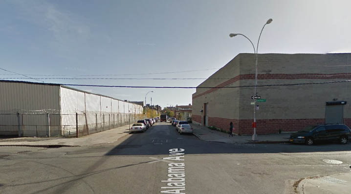
Alabama and Glenmore Avenues, 1966 and 2015 We're one block west. We're looking east along Glenmore, this time from Alabama Avenue. | |||||||||||||||||||||||||||||||||||||||||||||||||||||||||||||||||||||||

|
So what did this stretch look like before those industrial buildings went up? This image from the early 1940s (That banner was for parades supporting the troops around 1942) shows the stretch of Glenmore Avenue between Alabama and Georgia Avenue. The orientation is reversed, we are looking from Georgia Avenue toward Alabama Avenue. It came courtesy of Richie Rittmeyer and shows a real nice stretch of brownstones. | ||||||||||||||||||||||||||||||||||||||||||||||||||||||||||||||||||||||||

|
|
Alabama and Glenmore Avenues, 1966 and 2015 We are now looking south down Alabama Avenue from Glenmore Avenue. It doesn't get much starker than this. | |||||||||||||||||||||||||||||||||||||||||||||||||||||||||||||||||||||||

|

| Ashford Street, between Atlantic and Liberty, May 1966 and 2015 The view is north up Ashford Street toward Atlantic; the house on the right with the people in the windows was once the home of Linda Amato (I sent her the pic in case she recognized anyone).
|

| 
Ashford Street, between Atlantic and Liberty, May 1966 and 2015 |
The camera has swung 180 degrees and we are looking south toward Liberty Avenue. It looks like they filled in the gap between those buildings on the right but most buildings are still standing.
|

| 
Warwick Street and Liberty Avenue 1960s and 2015 | A familiar view to many site fans, looking east along Liberty Avenue towards Warwick Street. A sign advertising a St. Michael's bazaar is visible on the left. All the buildings on the right side are gone.
|

| 
Warwick Street and Liberty Avenue 1960s and 2015 | We've turned 180 degrees and are now looking west away from Warwick Street.
|

| 
Pitkin Avenue, west from Ashford Street August 1, 1966 and 2015 | We have a mix of some buildings standing and some gone as seen in the 2015 view.
|

| 
Barbey Street and Glenmore Avenue, 1960s and 2015 | Our first view is south down Barbey towards Glenmore Avenue. It's hard to see what's standing with the overgrown greenery.
|

| 
Barbey Street and Glenmore Avenue, 1960s and 2015 | Now looking east along Glenmore from Barbey towards Jerome.
|

| 
Pitkin Avenue west from Schenck Avenue, 1960s, 2015 | . In the early photo we can see the Lyric Theatre building still standing a block down on Hendrix Street. Most of the buildings in the early image are gone as seen in the 2015 shot.
|

| 
Van Siclen Avenue north to Liberty Avenue, 1960s and 2015 | We can see the Paragone-Bader Funeral home on the left, now I believe Funeraria Juan.
|

| 
Hinsdale Street and Pitkin Avenue, 1966 and 2015 | OK, now we swing way over west by the Brownsville border. The view is south down Hinsdale Street across Pitkin Avenue
|

| 
Hinsdale Street and Pitkin Avenue, 1966 and 2015 | The orientation is west along Pitkin Avenue from Hinsdale toward Brownsville. The remains of the Fulton Line which ran along Pitkin Avenue can be seen.
|

| 
Snediker and Pitkin Avenue, 1966 and 2015 | I placed these shots off Snediker and Pitkin here because they are similar views but sent me scrambling to my subway research. The picture on the left is the same view west down Pitkin, one block closer to Van Sinderen, and we see the same truncated portion of the old Fulton line. The view on the right is north up Hinsdale, and we see another truncated line-which I found confusing. See below.
|

|

Hinsdale Street and Pitkin Avenue, 1948 | Tom Appell came to my rescue with some corrections and better details on the layout. The original Fulton line came down Snediker Avenue and turned east on Pitkin Avenue. The Canarsie line would piggyback off the line in 1906, branching west off Snediker at Pitkin and continuing south along Van Sinderen. The 1916 improvements were not Dual Contracts work, but done by the NY Municipal railroad before it merged into the BMT. In the subway.org image on the left, we see two tracks running along Snediker; the one on the right is the northbound Fulton Elevated line, and on the left, a northbound Canarsie line track. Van Sinderen had 3 tracks supporting local and express service. On the right is a 1924 aerial view showing the tracks.
|
| Northwest corner, Hinsdale Street and Pitkin Avenue, 1966 | A closeup.
|

|

Belmont Avenue east of Hinsdale Street, March 18, 1965, and 2015 | We also have similar shots of Belmont Avenue looking east taken from Snediker and Hinsdale Street(below).
|

|

Hinsdale and Belmont Avenue, 1966 and 2015 | Matching the view above, we are looking east. The 4-story brick building in the distance on the left was once I.C. Candy Co.
|

| This is a closeup of the building see on the southeast corner of Snediker and Belmont. |
|

| 
Snediker Avenue, looking north from Belmont Avenue, 1965 and 2015 | What struck me in this image and the one below was the number of old woodframe dwellings. Some of the ones on the lefthand side appear on the 1886 maps.
|
| 
South side of Belmont Avenue, west of Snediker Avenue, 1965 and 2015 | I wasn't sure which was cooler in the image; the car or the two Victorian-style houses that were built circa 1890.
|

| 
Hinsdale and Belmont Avenue, 1966 and 2015 | We have moved over one block to Hinsdale Street and are looking south from Belmont Avenue. That large brick structure on the right was the Premiere Theatre which was demolished about 1980.
|

| 
Sheffield and Belmont Avenue, 1966 and 2015 | Now we slide east along Belmont Avenue to Sheffield Avenue, with a view east along Belmont.
|

| 
Sheffield and Belmont Avenue, 1966 and 2015 | The camera is now turned south down Sheffield Avenue from Belmont. In the 1966 image, the corner building on the left belonged to Belmont Metals, which is still in business today, though that structure has been replaced. The big 4-story building on the right once belonged to Parker Stearns, a medical products manufacturer. It is still standing though all the windows are bricked in. More interesting is the building just past it on the right. It was originally constructed as the Sheffield Theatre, and the 2015 image shows all its beautiful brickwork. It operated from 1917 to 1931 and I've never found an image of it from that era.
|

| 
Hendrix and Belmont Avenue, 1966 and 2015 | Further east along Belmont Avenue, we looking east along Belmont at Hendrix Street.
|

| 
Van Siclen and Belmont Avenue, 1966 and 2015 | Turning 180 degrees, we are now facing west toward Van Siclen Avenue. | ||