|
        |
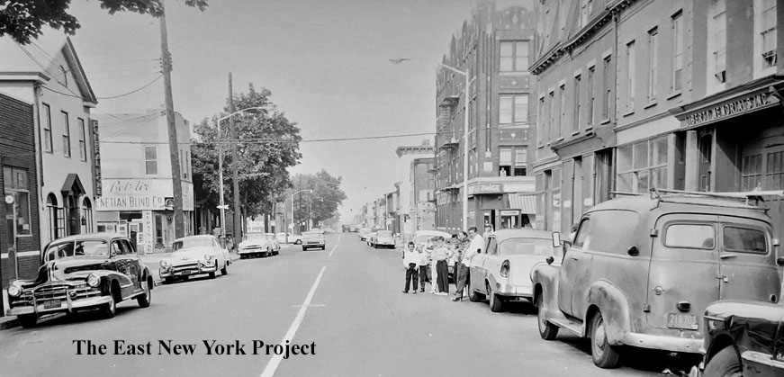
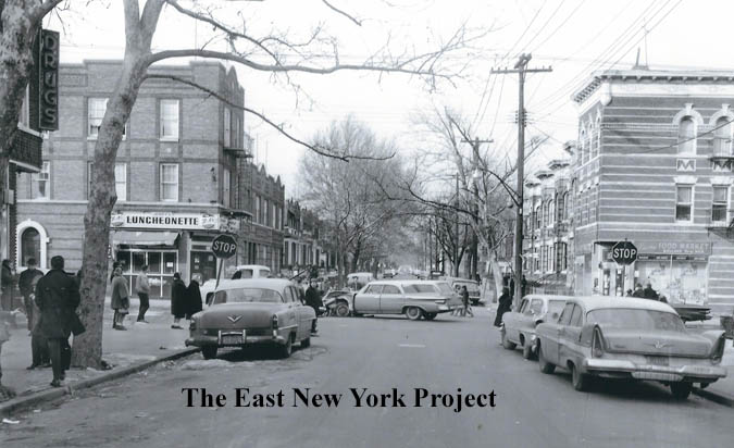
Zone 5South of Atlantic, west of Elton St. I have rearranged this page and have generally ordered the views from west to east. See the dropdown menu for specific streets, the Piels factory, the schools and the churches. |
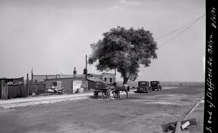
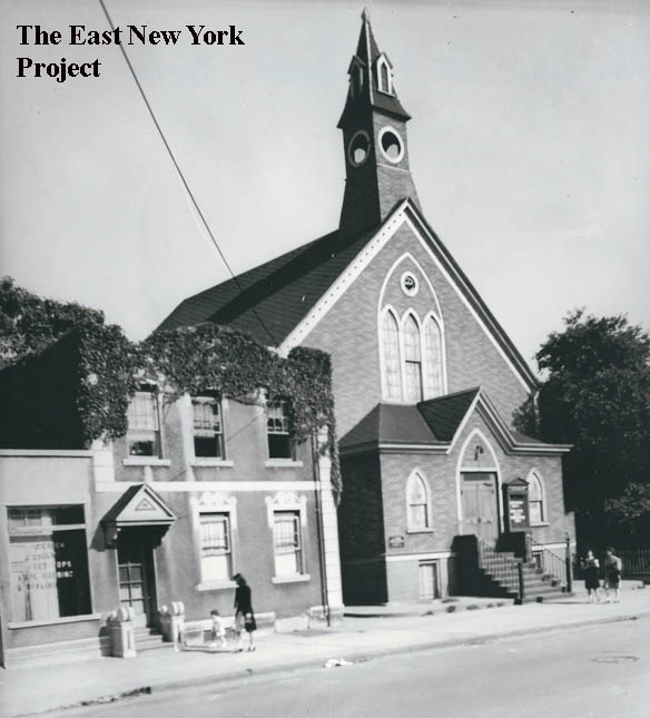
| Van Sinderen Avenue, formerly Vesta Avenue | |||
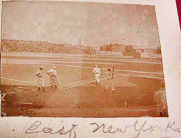  |
Eastern Park, 1893 Built in 1890, first used by the Brooklyn Wonders of the Player's League, it was next used by the Brooklyn Bridegrooms from 1891 to 1897. Patrons to the games had to be adept at dodging all the trolleys in the area and eventually the team name morphed to the Trolley Dodgers, and eventually, the Dodgers. Also used as a football field, it was the site of a classic Yale-Princeton clash on Thanksgiving of 1890, and one set of temporary stands collapsed under the weight of the crowd. The park was torn down in 1898, and is more or less an industrial wasteland. Pictures are rare and hard to find. The image above came from an 1890s photo album and was labelled "East New York" but we have not confirmed if it was the park. For more history, visit David Dyte's site |
||
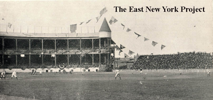 |
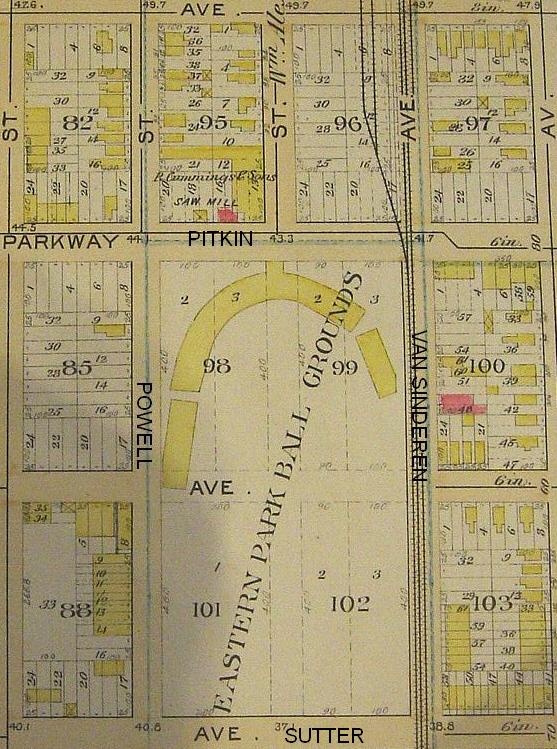
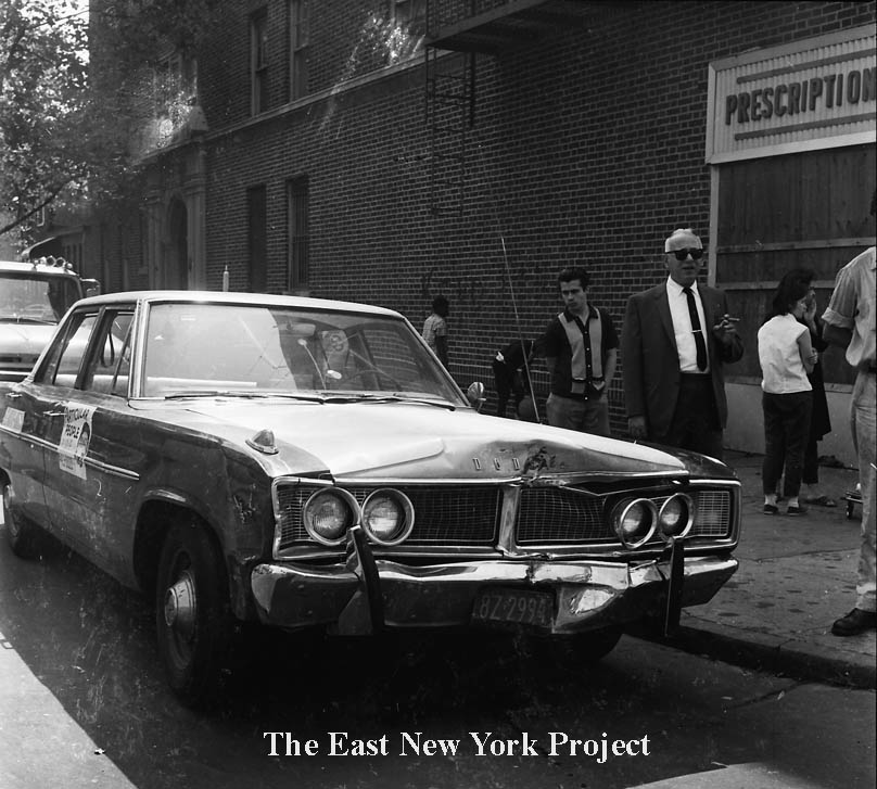
Eastern Park, 1894 We managed to find some images in an 1894 publication covering the start of Brooklyn's season. Using the map above, we are looking north toward the grandstands. |
||
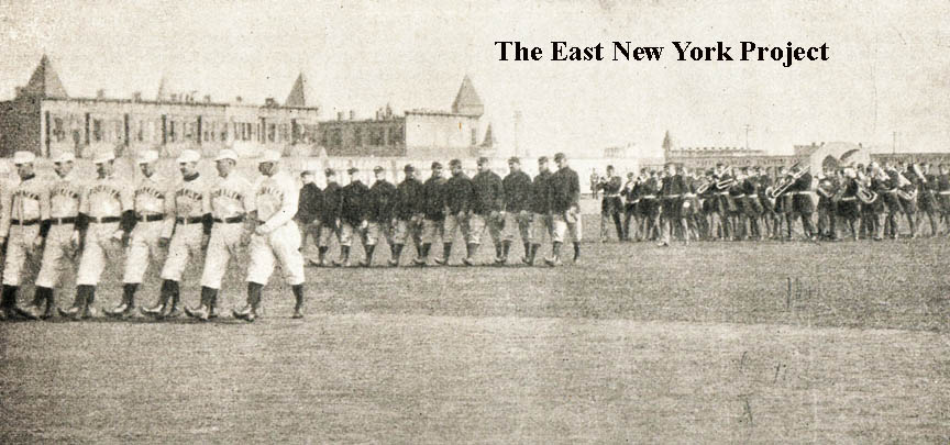 |
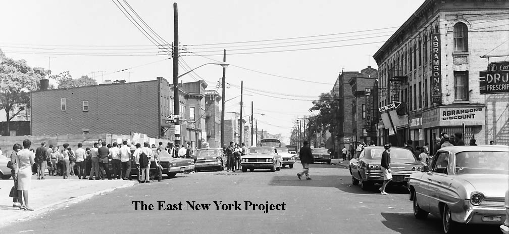
Eastern Park, 1894 The Bridegrooms march onto the field accompanied by a band. The view is southeast towards Sutter and Van Sinderen Avenues. |
||
| Snediker Avenue and Hinsdale Street | |||
 |
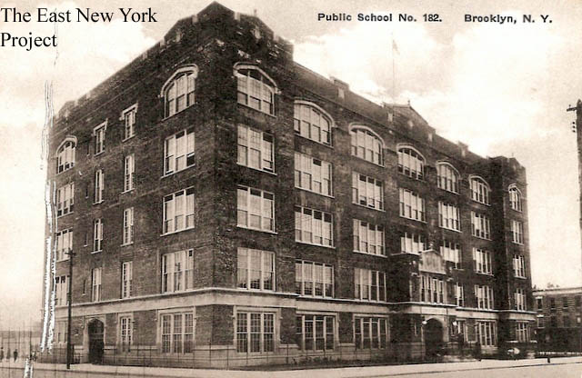
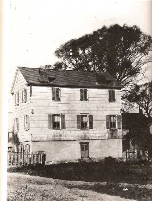
George Gershwin, 242 Snediker Avenue George Gershwin was born Jacob Gershowitz on September 26, 1898 at 242 Snediker Avenue. The 1963 Times article on the left details the dedication of a plaque on the 65th anniversary of his birthday. Despite the recognition, the house did not survive past the 1980s. In 1956, the newly opened P.S. 166 on Van Siclen Avenue and Linden Boulevard was named after him. |
||
 |
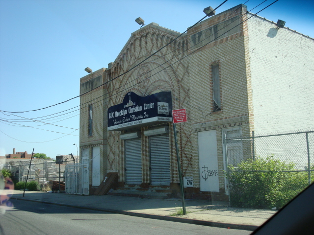 |
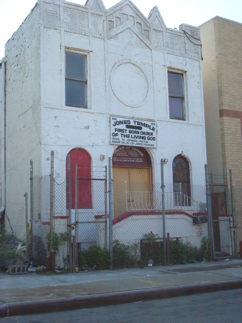
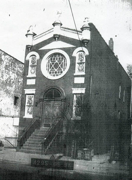
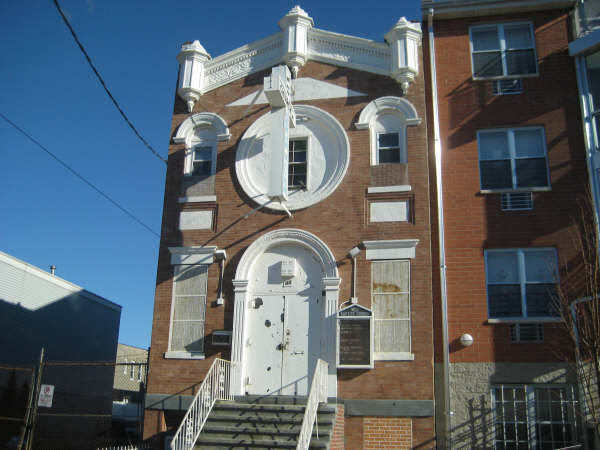
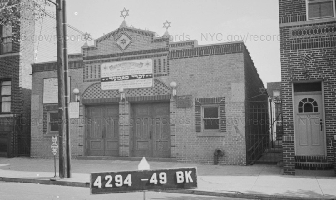
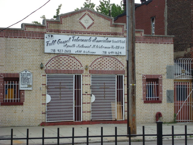
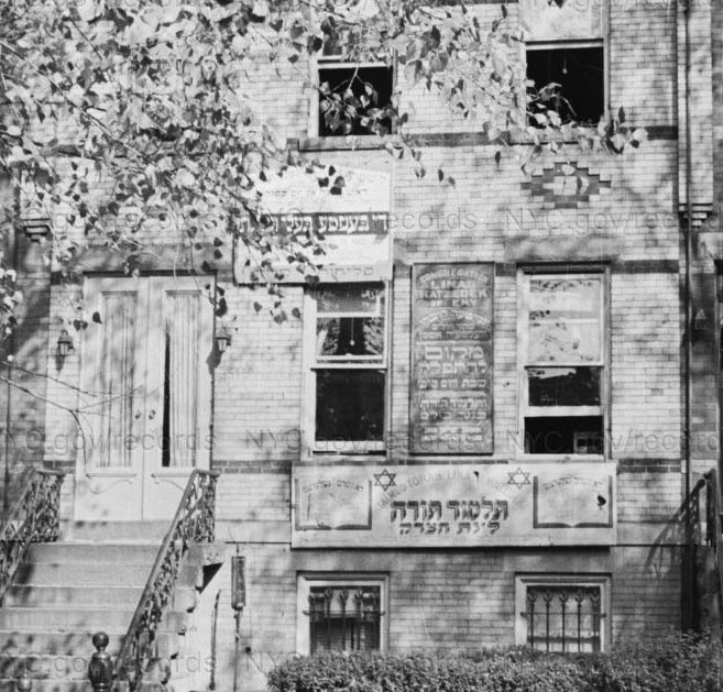
Synagogues Demetrius Pestun sent over two 2007 shots of defunct synagogues. Congregation Eliezer East New York was located on Hinsdale between Glenmore and Pitkin. Built in 1910, now the Jones Temple, First Born Church of the Living God.In 2013 this building was demolished and the 1940 tax photo now resides on the Lost Synagogues page. On the right, congregation Shevre Spahrd of Pereyaslov(Perevaslov is a town or city in ukraine). Located on Snediker between Sutter and Belmont, George Gershwin lived on this block. In 1967, it switched hands and is now the Brooklyn Christian Center. |
|
 |
Northeast corner, Snedicker and Belmont, 1943 Evelyn Israel supplied this shot of her with her dad and pet dog "Brownie" in 1943. . |
||
 |
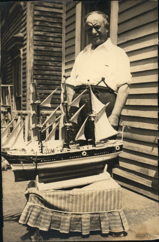 |
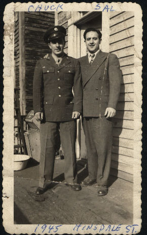
139 Hinsdale Street, 1945 Dan Bivona sent over these family pix of 139 Hinsdale, down near Glenmore Ave. These wood frame houses are long gone, replaced by an industrial area. The first shot is of Dan's father with his uncle Charlie, who is heading off to Okinawa in the summer of 1945. On the right is his grandfather Damiano, showing off one the ship models he built himself. |
|
 |
 |
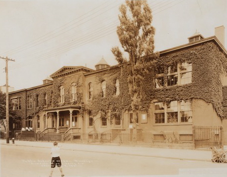
P.S. 63 The original P.S. 63, pictured on the left, was located at Hinsdale Street between Liberty and Glenmore. The center portion was built in 1878 with additions in 1900 and 1906. The "new" P.S. 63 on the right was built back to back to the old, facing Williams Avenue, in 1926. The old building became an annex to Thomas Jefferson High School. I do not have a date on demolition. The view is north in that shot. My mother attended P.S. 63. |
|
 |
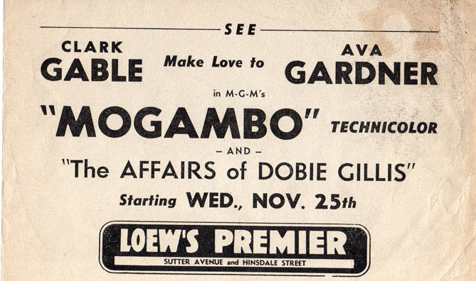 |
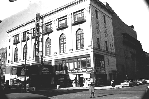
Premier Theatre, Hinsdale and Sutter Avenue The Premier opened in 1921, designed by Charles Sanblom with a seating capacity of 2,580. Loew's took over the theatre in 1926 and ran it until 1963. The Premier's large seating capacity allowed it to host graduations, beauty pageants, etc. Phil Silvers would sing on amatuer nights at the Premier. The picture on the left is from 1967, when it was part of the United Artists Circuit. The handbill is from 1953. After the blackout of 1977, the Premier closed its doors for good. Most of this stretch was demolished about 1980 and awaits development. |
|
| Williams Avenue, separate page, click here | |||
| Malta Street and Alabama Avenue | |||
 |
 |
Synagogues At 43 Malta (original deed has it as 41) stood the Alleppo Congregation Agudeth Achim Anshei New Lots, founded in 1911. The land, was donated in 1911 by Samuel Greenberg, and the deed had a covenant stipulating that 2 seats were reserved for him and his wife Lena (whose seat was in the balcony.) It further stipulated that a tablet affixed to the outside of the synagogue would acknowledge the donation and could never be removed. These stipulations had to be removed by consent of his descendants in 1965 in order for the building to be sold. The 1941 tax photo sent in by JoAnn Montgomery shows the Jewish star in the circular window, now hidden in the current picture sent in by Demetrius Pestun. Sold to the West Baptist Church of Brooklyn in 1966. |
|
 |
Synagogues Just down the block at 71 Malta was the Synagogue of Friendship Truth and Brotherhood Kastorialis. According to Ellen Levitt, this was a Sephardic (Levantine) synagogue. Thanks to Demetrius for the current photo, now the Church of God of Prophecy. |
||
 |
 |
Former synagogue Dorchei Tov Anshei, Louisiana Street Founded 1917, First Rabbi Portnoy (1917-1919). The congregation rented space on Linden Boulevard until this building was constructed at 23 Louisiana in 1923. Sold to the Gospel Tabernacle Church of God in 1967 and continues in use today. Thanks to Wendy Griswold for the historic details. |
|
 |
 |
Liberty and Alabama, 1960s The first view is west along Liberty Avenue from Alabama Avenue. The second view is south down Alabama from Liberty. |
|
 |
 |
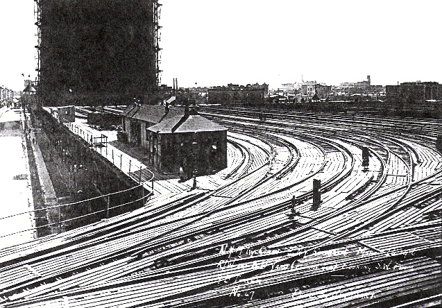
Alabama train yard On the right is an early 20th century view looking down from Highland Park and we have tried to identify that tank in the distance. Neil Sullivan provided this shot of the Alabama train yard before 1920, and this certainly could be that tank. The yard was bounded by Alabama, WIlliams, Belmont and Sutter and serviced the Fulton Elevated line. The tank, however belonged to the Brooklyn Union Gas Company. |
|
 |
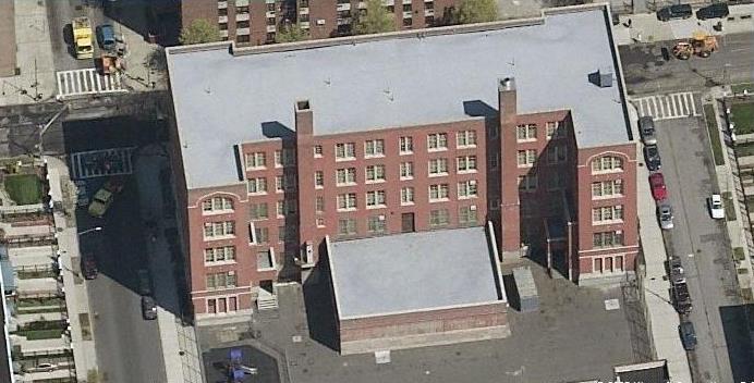 |
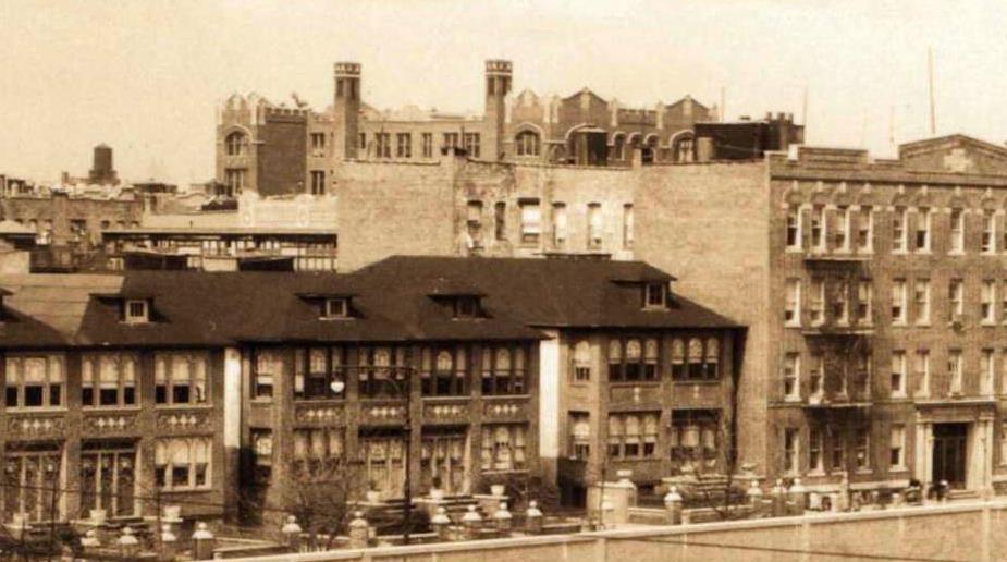
P.S. 174 Located on the south side of Dumont Avenue between Williams and Alabama, P.S. 174 dates back to 1913. I was more interested in the rear of the building, which featured an unusual double chimney as part of its original architecture. In the early photo on the left from the 1930s the building is in the distance but you can see the unique roofline and chimney caps. The roof underwent a major renovation in the 1990s, I'm not sure that's when all the detail was lost but in the Local Live photo on the right you see see the roofline has been flattened. It still functions as a New York public school today serving grades K-8. |
|
 |
 |
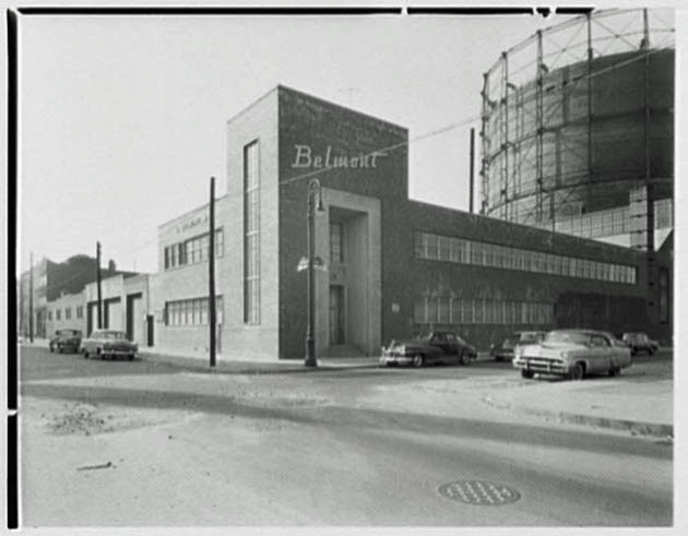
Belmont Metals Belmont Smelting, now Belmont Metals, dates to 1896 when George Hennigan started his scrap metal business on Belmont Avenue between Georgia and Alabama Avenues. The Hennigan family is still involved in this business, and my brother Lou sent over this January 2010 Times article about the business. The photo on the left is from 1955. |
|
| Georgia Avenue has its own page, click here | |||
 |
 |
8mm Film, St. John's and Georgia Avenue This serves as a reminder that we have individual pages now for Georgia Avenue and St. John's Church on New Jersey Avenue. The first video is a wedding at St John's, with views primarily north up New Jersey Avenue in April 1947. The second film is of Georgia Avenue between Liberty and Atlantic around 1950. First Video:  Second Video: Second Video: |
|
 |
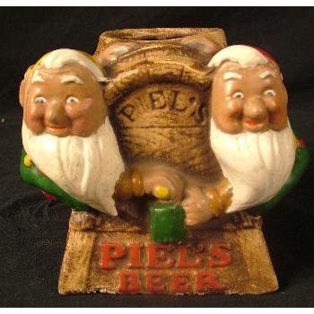 |
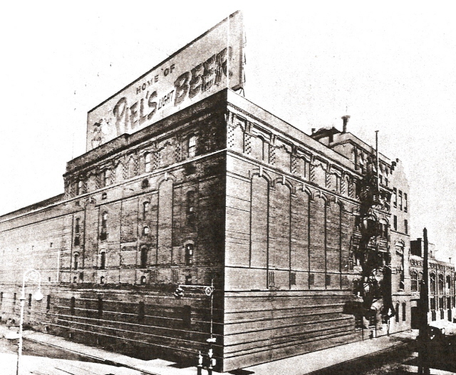
Piel's Brewery, 1947 Located off Georgia Ave. , the Piels Brewery had a famous neon advertising sign atop the building. Prior to using the "Harry and Burt" advertising scheme, the Piels Co. used gnomes in their advertising, pictured on the right. These gnomes could be seen in the neon sign "bowling" as the lights changed. Thanks to the assistance of Breweriana collector TJ Wiegand, we have a page dedicated to the Piels brewery . |
|
| Sheffield Avenue | |||
 |
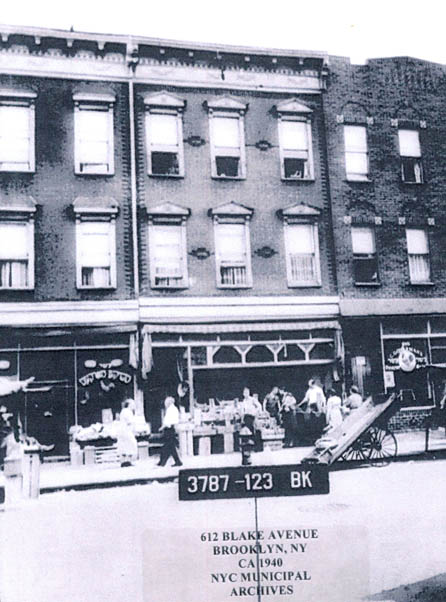 |
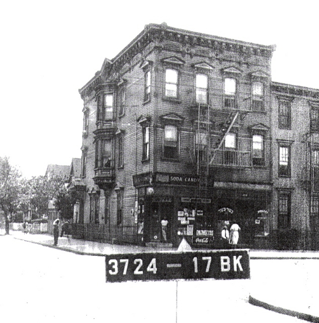
Pushcart Vendors Slightly out of synch here; 564 Blake near Williams on the left and 612 Blake near Sheffield Avenue on the right. A descendant of Sussman Pickles at 612 Blake Avenue provided this tax photo of the family business and reminded me I had a book outtake photo of Blake Avenue a few blocks west also showing pushcart vendors. |
|
 |
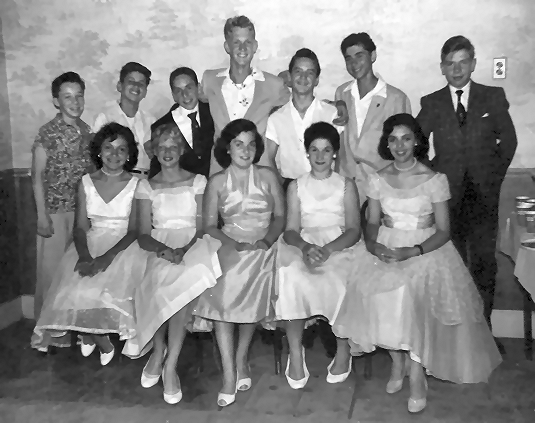 |
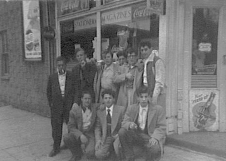
Sheffield and Glenmore Richie Rittmeyer supplied a 1941 image of the corner; "That's my mom and dad, Vincent and Gertrude Rittmeyer, with me in the carriage. You can see some of the Piels Brewery plant in the background. On this corner, there were two businesses - Stupplers on the southeast and Eisenbergs on the northeast, both involved with auto slip covers. Very big at the time." On the right, a P.S. 149 1956 graduation party pic at his home at 181 Sheffield Avenue; "Boys - Left to right - Selwyn Alpert, Dennis Kurtz, Stu Bailin, Me, Charlie Paris, Melvyn Tirshfield and Daniel Sclafani. Girls - Left to right - Joann Chichetti, Leona Ramoska, Nina Rallo, Bernice Levine and Martha Bivona" |
|
 |
 |
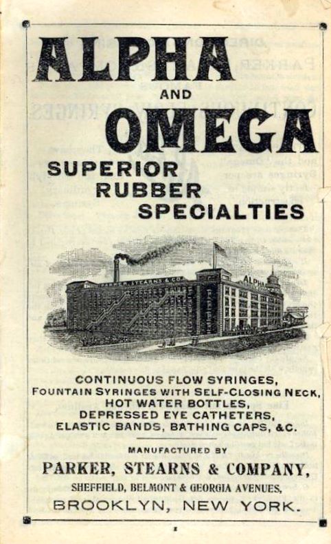
Parker Stearns Manufacturing My brother stumbled on this old medical products brochure which was only interesting for the image of a magnificent factory on the cover. Located on the south side of Belmont Avenue between Georgia and Sheffield the company existed into the 1930s. There were COs issued for a glue manufacturer in the 1940s and I believe the building is still standing, partially obscured by adjacent buildings in the Local Live image. |
|
 |
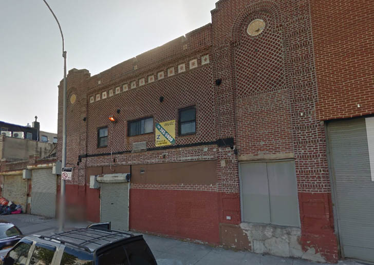 |
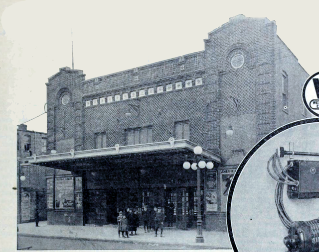
Sheffield Theatre Two buildings down from Parker Stearns was the Sheffield Theatre. It operated from 1917 to 1931. Kudos to Mitch Kahn for digging up a picture, probably circa 1918. It appears to be from some sort of Westinghouse Electric ad or publication. Fred Weiss reached out to me; "my father Mickey Weiss bought the Sheffield Theatre in the 1930s and converted it into a Plumbing Supply. He also bought the Parker Stearns building in the 1970s and moved the business in there." The building remains standing, it appears to have been used as a warehouse for some time. |
|
 |
 |
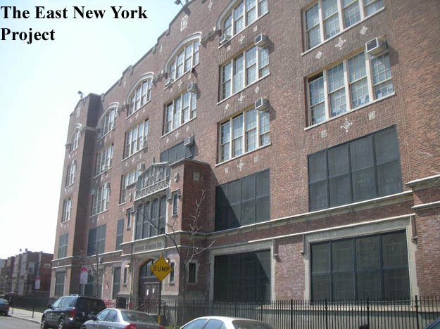
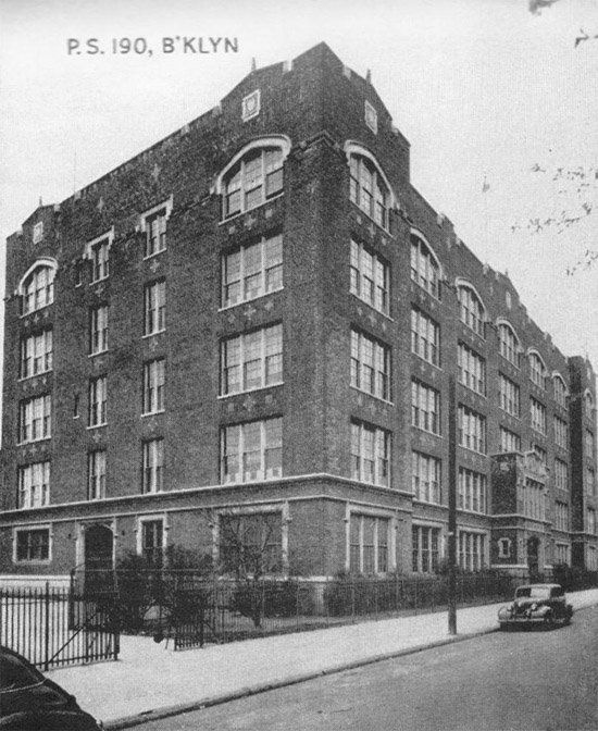
P.S. 190 Constructed in 1924 on Sheffield Avenue between New Lots and Riverdale Avenues, and still in use. "Subway Al" Zelazo is the first to submit a P.S. 190 contribution, his mother's graduation class picture from 1945, as well as her ring (right). 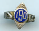 |
|
 |
 |
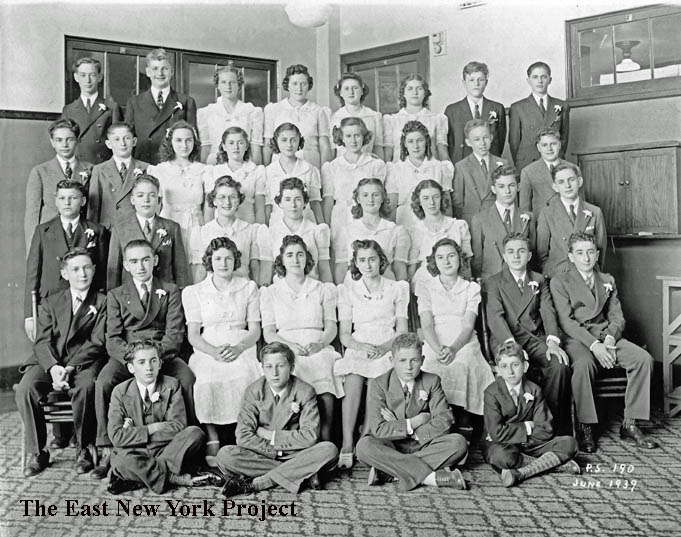
P.S. 190, 1939 and 1943 Thanks to Steve Monroe for these early class pictures. He identifies Rene Moucatel in the top row, third from right in the 1939 picture and her brother Isaac, top row, second from right in the 1943 image. |
|
 |
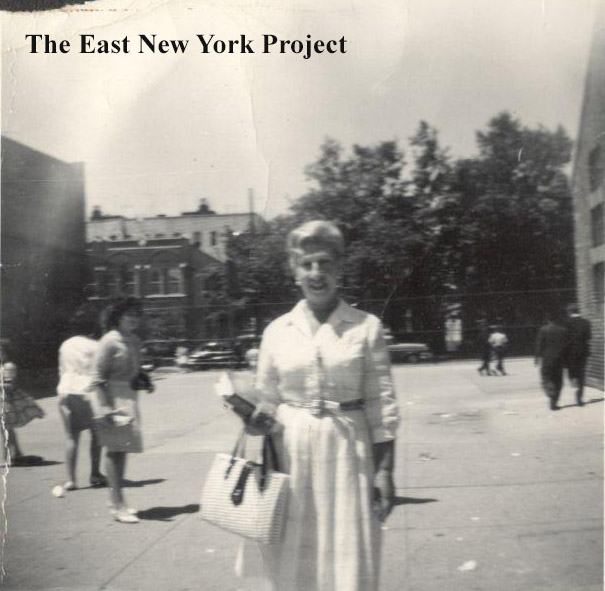 |
P.S. 190 Wendy Griswold sent this circa 1940 image of the school from her autograph book, and a picture taken of a beloved teacher, Lillian Ingber, in the schoolyard during Wendy's 1962 gaduation. |
|
 |
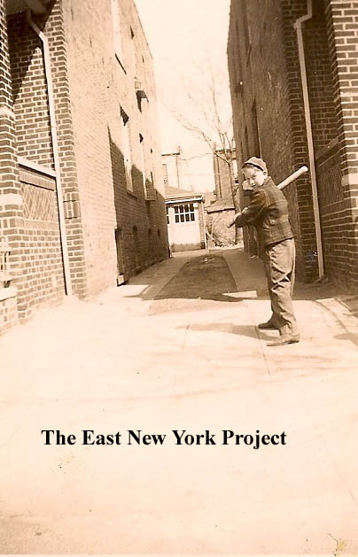 |
P.S. 190 Howard Rubin sent in this photo of his 6th grade class in 1946 outside of the school. Howard noted by this point in time the school only went up to the 6th grade, as the upper grades had been moved into the junior high school system (in that area it was 149). On the right, Howard is pictured across the street in the alleyway alongside 567 Sheffield, circa 1945. |
|
 |
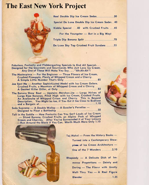 |
Sol's Howard Rubin also sent in this menu for Sol's, famous for their frappes. Located on the the corner of Sheffield and New Lots Avenues, I was intrigued by the menu. The "Joe Sent Me" and the "Tall in the Saddle" are creations I remember from Jahn's ice cream parlor in Richmond Hill. I wonder if there was a connection. |
|
 |
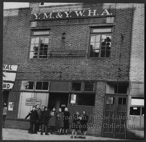 |
YMHA Howard took this picture of Sheffield off New Lots; on the left is where Sol's was located, and the bricked up building was the YMHA. I recalled from my research that they opened the first local community library there in 1949, and found an image of the building just after the opening . |
|
 |
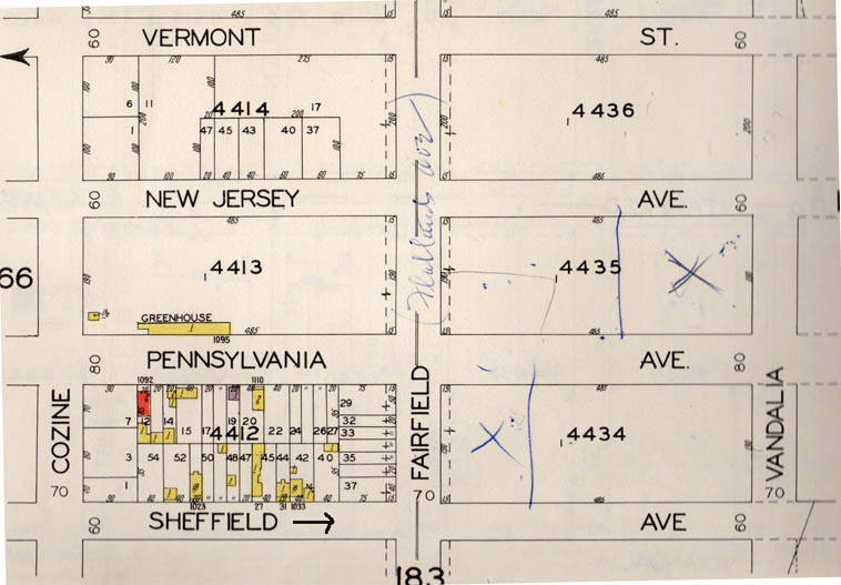 |
Sheffield and Flatlands Avenue, 1929 When the Geller family sent in a picture of Sheffield Avenue looking south toward Flatlands Avenue in 1929, I was surprised to see anything that far south at that time. So I went to the maps and it seems that was pretty much the only block with buildings in that area (note Flatlands Avenue was known as Fairfield Avenue at that time.) |
|
 |
 |
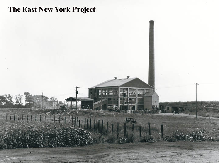
Sheffield Avenue, 1934 These images were taken in 1934 by Percy Loomis Sperr, showing an incineration plant by Sheffield and Wortman Avenues and the "end" of Sheffield Avenue at that time. |
|
| Pennsylvania Avenue has its own page, click here | |||
 |
Hegeman and Pennsylvania Avenue, circa 1942 This shot came from Howard Rubin. It was taken in front of a drug store on Hegeman and Pennsylvania Avenues around 1942. Howard IDs Murray Finkel, middle - top row, who fought in Anzio and was wounded in southern France. He also IDs Herman Rubin, top row right, who served as a weatherman in the Pacific. It is the signs in the background that intrigued me. "Buy blades now while we have" is a WW II timestamp. "Rent to Read Lending Library" was explained to me by Howard. There was no library down in the New Lots area at that time, so stores would stock popular titles and rent them out. The I.O.W. sign on the left stood for International Order of Workers, a communist -led organization that provided health insurance, mutual benefits and social organization. Howard added; "The IWO, known as the Wobblies was a left wing labor organization, which still has a small membership, according to an article I recently read in the NY Times. It is mostly defunct. They probably had a health plan which that drug store subscribed to. Remember, after WWII the left wing American Labor Party was strong in ENY. They even had a few elected politicians and were very active in the 1948 presidential election by supporting Henry Wallace. I remember a rally was held in Jeff Field, on Pennsylvania Avenue between Livonia and Riverdale Avenues, where Henry Wallace spoke. I would bet that he garnered many votes in the Jewish areas of ENY and Brownsville." . |
||
| New Jersey Avenue has it own page Click here. | |||
| Vermont Avenue | |||
 |
Pitkin Avenue, west across Vermont Avenue, 1959 On the left we can see Dan Luries's Vermont Moving and Storage warehouse; the architecture tips you off that it used be an old movie house. Constructed about 1916, the Vermont Theatre did not survive the talkie era and the property was in bankruptcy court by 1932. The entire block was cleared for the Grace Playground in the 1970s. The A&P on the right continues on today as a C Town supermarket. |
||
 |
 |
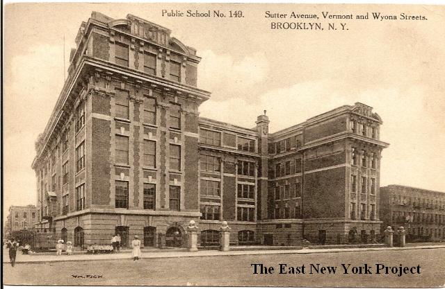
P.S. 149, Vermont and Sutter Ave. Dated: 1912 Maker: Wm. Fick Status: own(BG)< Neil sends in the 2006 shot. Built in 1906 and still standing, now known as The Danny Kaye School as well. We have a page devoted to 149 here. |
|
 |
Duke's Candy Store, Vermont and Glenmore 1952 Off the southeast corner, Rod Maggio IDs the gang posing in front of the store- "Jr." Baxter, "Whitey" Emmet, Albie Hennigan, Henry "Buzzy" Caron, Rod, and in front Jim McCance, Phil Cipriano, Ron Quintavalle. Tony Pomillo recalls: "..I worked for Duke & his brother in law Rocky for a while. My job was to get the "News" & "Mirror" from old "Blind Charlie" on the corner of Pennslyvania & Sutter and bring them back to the store in addition to helping out behind the counter." |
||
 |
Glenmore Avenue, looking west toward Vermont Street, 1940s Courtesy of Brian Merlis, back then it was Vermont "Street" though I am unsure as to when it changed to "Avenue". |
||
 |
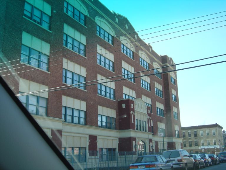 |
P.S. 182, Dumont and Vermont Ave. Maker: Albertype Dated: Unk Status: Own(BG) Ellen Grove reminded me that P.S. 182 sat down on Dumont Ave between Vermont and Wyona. In 1920 it was listed as 'under construction' and was actually converted into low income condos called The Dumont in 1999. Ellen took the 2006 picture on the right and supplied some memories. Sid Bloom tipped me off science fiction author Isaac Asimov attended 182. Wendy Cade also adds some memories including the school song.  |
|
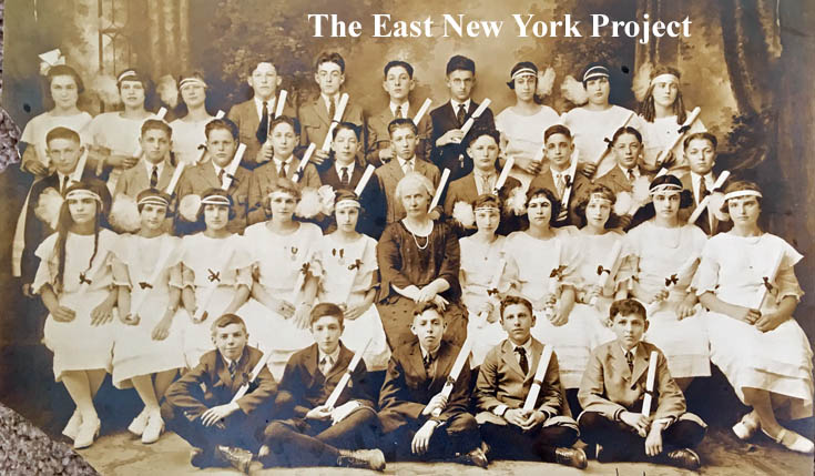 |
Graduating class, P.S. 182, 1922 I haven't come across many class pictures of P.S. 182, but Hal Bailis supplies a gem- his father's 1922 class picture. Hal's dad is seated front row on the far right. Hal also supplied a little info on the headbands of the female classmates; they were quite popular during the era, sometimes known as brain binders or headache bands. |
||
 |
East New York Jewish Center Talmud Torah I copied this over from my "Lost Synagogues" page. Menachem Nussem, who lived across the street from this synagogue which was located at 374 Vermont Street, helped me out with a great deal of background. In Menachem' s time (1950-1963) it was never a Talmud Torah (a place children who attended public school would go to study the Torah after 3 PM.) It was a synagogue led by Rabbi Yitzchak Pupko. " I can tell you this with absolute certainty. There weren't many Rabbis with his level of scholarship. He was a major player, when it came to Jewish law (civil as well as religious). When one of the Israeli Chief Rabbis visited here, he met with Rabbi Pupko...It was customary for the Rabbis to test each class in elementary school a few times a year. It was an oral test... These tests were in Yiddish. Rabbi Pupko and many other Rabbis, hardly spoke any English. In those days, if you went to Yeshiva, you had to master Yiddish." |
||
 |
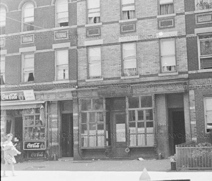 |
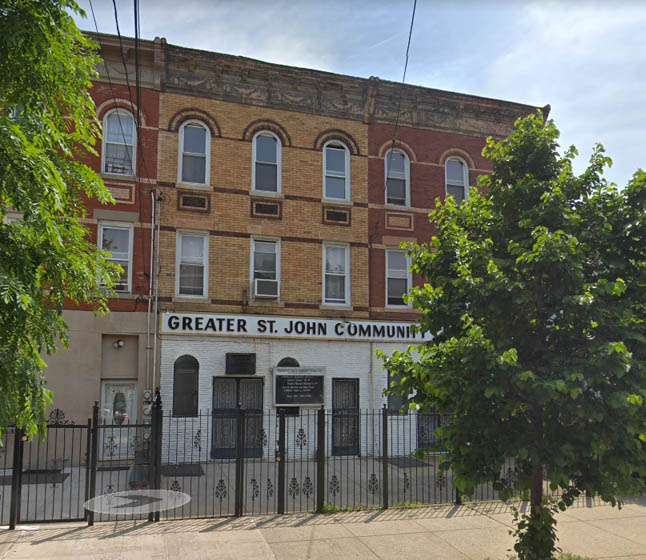
Greater St. John Community Church, former Anshei Krasnikof 471-473 Vermont Street are adjoining 3-story buildings. Congregation Anshei Krasnikof was formed by immigrants from the town of Krasnik in Poland. One source has the congregation dating to 1897, Ellen Levitt's book has it organizing in 1919. The 1940 tax photo on the right shows the ground floor of 471 Vermont still operating as a candy store while the building next to it was possibly acting as a storefront synagogue. Ownership transferred about 1968. |
|
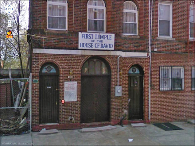 |
Richard Woitowitz tipped me off to a synagogue a block away from P.S. 182 at 744 Dumont Avenue. What's amazing is that it appears to still be in use as a synagogue! It was Ohev Shalom ("Lover of Peace") but was sold to First Temple of the House of David in 1975. It was a relatively new one, forming in 1949. | ||
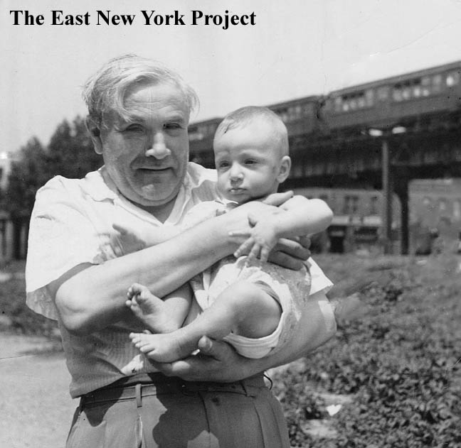 |
Bill Sofer sent this image of his grandfather holding him in 1941; the view is northwest on Vermont Avenue and the Livonia El is visible in the background. | ||
 |
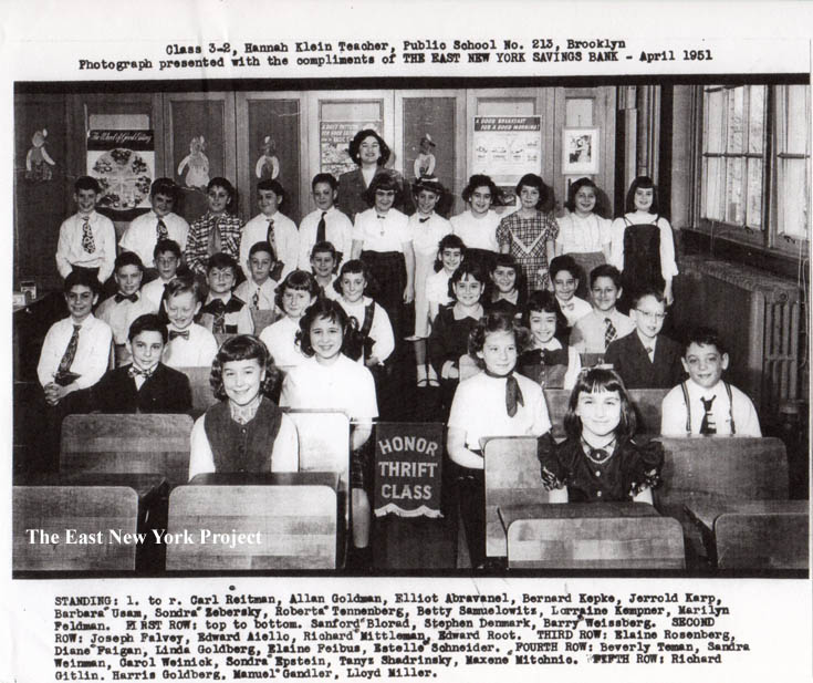 |
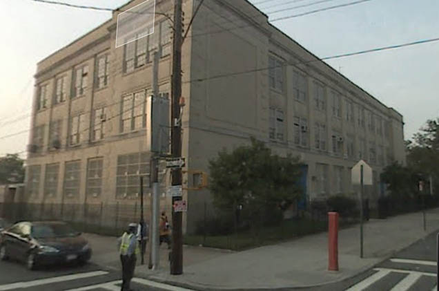
P.S. 213, 580 Hegeman Avenue, 1951 Thanks to Evelyn Israel for helping us add this school to the site. P.S. 213 has a unique place in ENY history; due to demographics, the Depression, and WWII, it was the only elementary school built in the area from 1930 to 1952. Located between Vermont Street and New Jersey Avenue, Evelyn supplied an East New York Savings Thrift class picture from 1951. |
|
 |
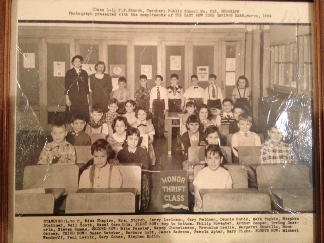 |
P.S. 213, Class 1-7, 1951; Class 1-1, 1954 Also from 1951; Sam Leftow sent in an ENY Thrift Savings Class picture for his sister's class 1-7. On the right, Neal Cassoria supplied a 1954 pic. |
|
| Wyona Street | |||
 |
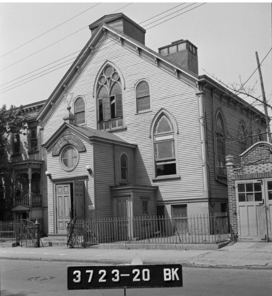 |
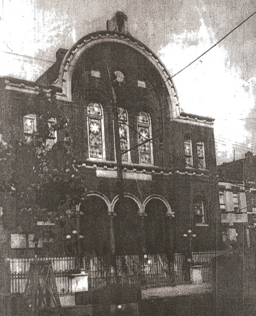
238 Wyona Street is situated between Glenmore and Pitkin Avenues. This structure was dedicated May 20, 1889 as St. Paul's German Evangelical Lutheran Church, built at a cost of $9,000. The congregation only lasted here about 20 years and the building was sold to the Congregation Achim Bnai Jacob around 1907. They would construct an impressive synagogue on the corner of Glenmore and Miller in 1922, which today serves Calvary Baptist Church. Congregation Chevre Mishnayes moved into the Wyona Shul and their sign can be seen in the 1940 tax photo on the right. Dr. Steven Kritz would visit this synagogue in the 1950s with his great uncle but recalls the building had been modified significantly by then; " I remember that I had to walk up a very wide wooden staircase that was more than a story tall in order to get into the Shul. Once inside, I would have to walk a slightly downward sloping aisle (or aisles) to get to the Bimah. I'm not certain; but I believe that the women would have to go up an additional flight to a balcony sitting area; although I don't recall ever seeing a women there. In fact, there were barely enough men to make a Minyan. I also recall that my uncle was the only man who didn't have a long beard. He was always clean shaven. "The early photo on the left is from 1917 No longer standing, the empty land is owned by the St. Augustus Roman Catholic Church. | |
 |
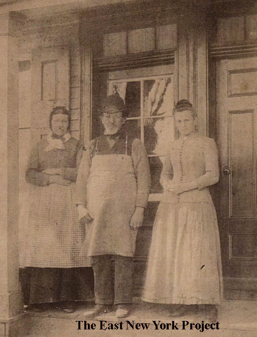 |
Some very cool early history has been supplied to us via Catherine Alt O'Neill. Her great-grandfather, Peter Alt, came to New Lots about 1862 and purchased a tract of land from the Wyckoff family just south of today's Pitkin Avenue by Wyona Street. On early maps the tract was identified as "Alt's Meadow". He built the frame house on the left at 286 Wyona Street (then Wyckoff Lane) and was a shoemaker. The picture on the right, taken circa 1880 in front of his shop, shows Peter between his wife Elizabeth and daughter Mary. Peter would squeeze the second house (with the flag) in the 1880's for his son Charles. Charles, Catherine's grandfather, would eventually serve as an alderman and a senator. The homes were cleared in the 1960s for the construction of I.S. 292. | |
 |
 |
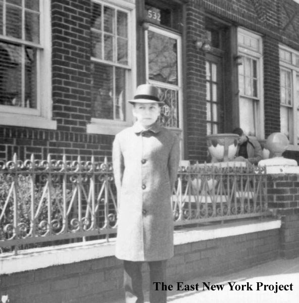
532 Wyona, 1963 Rich Woitowitz sent us a wealth of photos and these give us a view of Wyona south of Dumont Avenue. On the left, sporting his "Tom Landry" look, Rich stands infornt of his home at 532 Wyona. On the right, sporting what I would call his "Fidel Castro" look, we see Rich in a view south down the block. The tall fence on the left surrounds the playground of P.S. 182. |
|
 |
 |
Wyona Street, 1965-66 These two views of Rich and his mother Helen provide additional views of Wyona in the mid-60s. On the left, a view at the south end with the IRT in the background. On the right, a view across from 532 Wyona. |
|
 |
Wyona Street, 1947 Richard also supplied an earlier image of Wyona between Blake and Dumont, around 1947. Those are his maternal grandparents Olga and Peter Zybrick near 434 Wyona. |
||
 |
 |
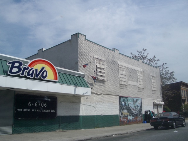
Biltmore Theater, Wyona and New Lots Avenue The Biltmore was opened in 1927 and closed in 1971. The building sat empty for a number of years in hopes of revitalization, but was finally demolished sometime around 2000 (I'm looking for confirmation of that). It is now a parking lot for a local supermarket. |
|
| Bradford Street | |||
 |
 |
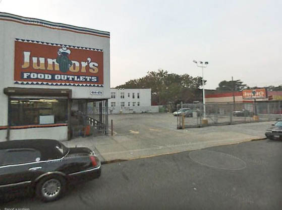
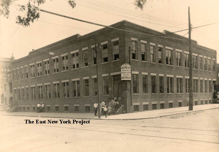
Duman Textile, Liberty and Bradford This picture dates to 1915. The view is the southeast corner and on the far left is the police station. The building is still standing and serving as a church, as seen on the right. |
|
 |
 |
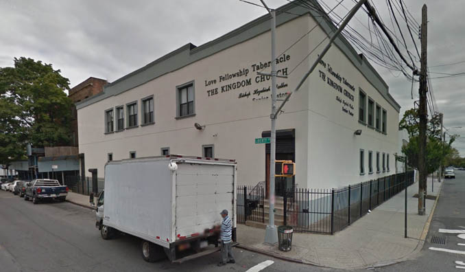
351 Bradford Street, former Congregation Linas Hatzedek 351 Bradford, between Blake and Sutter, stills stands today as a private residential building. From 1930 to 1940, it was the home of Rabbi Joseph Bauman and his congregation, Linas Hatzedek V'eras Achim. They moved to 341 Pennsylvania Avenue, which can be seen on that page. |
|
 |
 |
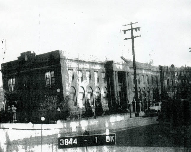
Riverdale Hospital I stumbled on Riverdale Hospital while perusing the 1929 Plat maps. Built on the triangle formed by Bradford, Miller, Riverdale and New Lots Avenue, the history of the hospital is elusive. Apparently it was privately owned. In the obituary of Dr. Maxwell C. Katz, he was not only the attending obstetrician and gynecologist but owner of the hospital until he retired in 1944. Patrick Gilmartin tipped me off that when he worked there in the early 1950s, it had been taken over by Manhattan General and was being used as their tuberculosis annex. Somewhere after 1955 the hospital becomes Linden General, run by Stanley Sharfstein. The hospital loses its accreditation in the mid 1970s, though it continues to run, creating a scandal. By this point its main revenue source is Medicaid. The building winds up in bankruptcy court in 1976, and the city took it over. It was reopened in 1987 as a day care facility. Looking for further information. |
|
 |
 |
Southwest Corner, Glenmore and Bradford Neil Sullivan sends over a 1939 tax photo of a former residence of his father-in-law. Though the picture is weak, it does tell a tale. There is a candy store on the corner, and a Jewish butcher shop next door. By the 1950s, the stores are boarded up and used for storage. In 2006, an empty lot. |
|
| Miller Avenue | |||
 |
 |
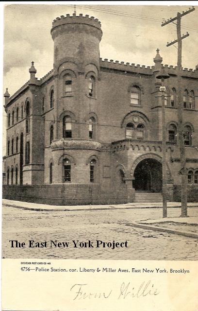
Police Station, Liberty and Miller Dated: 1908 Maker:Souvenir Post Card Co. Status: Own (RG) A current resident and fan of the site sent in a current photo; apparently it was a church for awhile. The station, designed by George Ingram, was constructed in 1892 for what was then known as the 17th Precinct. The 75th Precinct is now located on Sutter between Linwood and Essex (thanks Rod). Check out the story on the old police station. |
|
 |
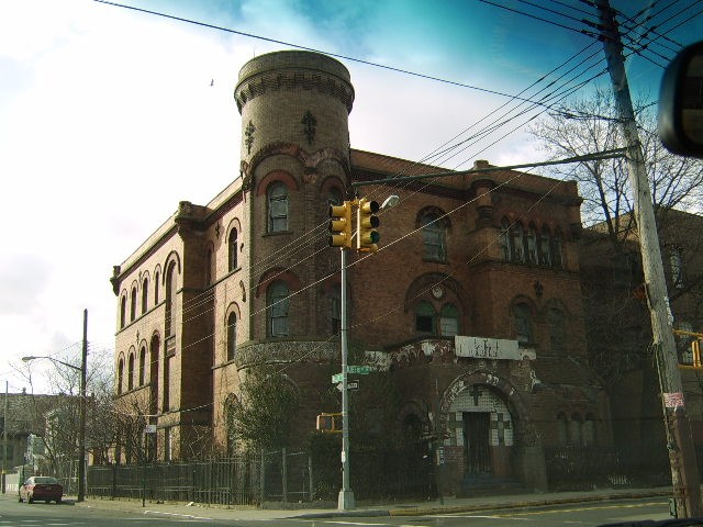
Miller Theater, 1941 Located on the north side of Sutter Avenue, between Bradford Street and Miller Avenue, the Miller opened in 19126. It closed in 1956, replaced by a factory. |
||
 |
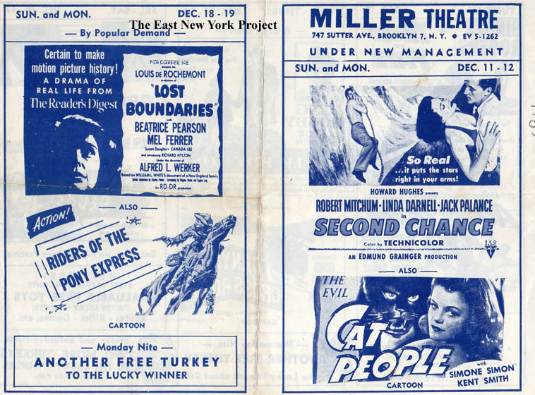 |
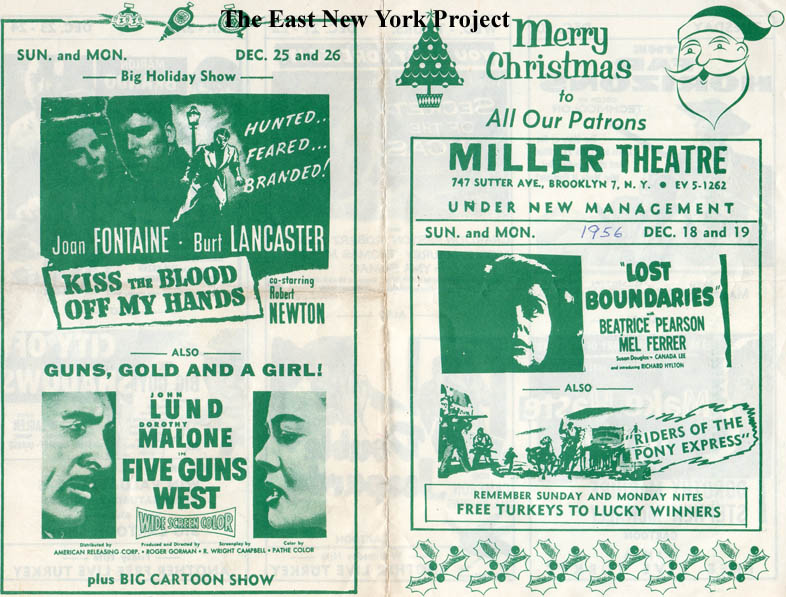
Miller Theater ads, 1956 Although the Brooklyn Theatre Directory lists the Miller as closing in 1956, we found these flybills advertising new ownership and programs in December 1956. Note the free turkey raffle. |
|
 |
Temple Achim Bnai Jacob Demetrius Pestun is helping us backfill the missing synagogues from the site. On the left in Temple Achim Bnai Jacob. The congregation first worshipped at 238 Wyona, seen above. Located on Glenmore and Miller, it was built in 1921 and is now I believe the Second Calvary Baptist Church. |
||
 |
 |
Glenmore and Miller, 1960s From the "accidents" series. The first view is south down Miller Avenue across Glenmore Avenue, the second view is east along Glenmore from Miller. |
|
 |
 |
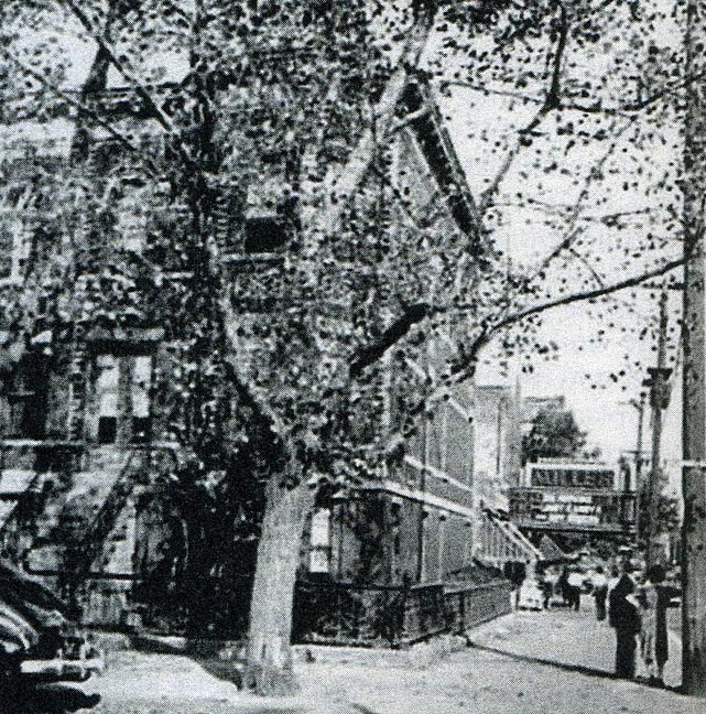
Miller Ave., 1944,1956 Dan Bivona sends over this shot of his grandparents, Sal and Josephine Aresco, on Miller Ave looking north towards Pitkin. On the right, Dan is standing in front of 370 Miller circa 1956.Dan recalls there was a theater on Miller down by Sutter Avenue; I have identified it as the Miller Theater at 747 Sutter. No longer standing, it was issued a CO in November 1926 and again in 1928 for a 575 seat theater and stores. In 1956 a CO is issued at the address for stores but no mention of a theater. Rod Maggio recalls it lasted into the 1960s. |
|
 |
 |
Miller Park, 1954 Rich Woitowitz is the first to send over pix of this park, which is bounded by Miller, Bradford Street, Blake and Dumont Avenues. This park was known as Linton Park and dates back to the late 1800s when Edward Linton and his German-American Improvement Co. was developing the area. When I checked on Google Maps, I noted it was still referred to as Linton Park today. |
|
 |
 |
Northeast corner, Miller and Pitkin Neil's father-in-law lived in the house next to Miller's Meat Market, you can see the stoop in the 1939 photo. |
|
 |
 |
Miller Avenue, south of Sutter Avenue From the 1967 blizzard series, this one drove me crazy; the brickwork was unique, and I even had an address number, "449", to work with. But it took days poring over insurance maps to find possibilities, and I'm glad to say those nice buildings are still standing. It is the east side of Miller at the top of the block. |
|
| Van Siclen Avenue | |||
 |
 |
G. Sommers Dairy, Southwest corner Van Siclen and Liberty Avenues, ca. 1900 This building appeared on the 1884 maps and was still around 100 years later. The corner was cleared in the late 1990s and the lot remains empty today. Looking down Van Siclen Avenue, I believe only the 3-story woodframe remains standing today. The next building down with the upper level porch intrigued me so I dug up the 1940 tax photo. Though built as a private home, by 1940 it was serving as the headquarters for the Jewish-American Democratic Club of the 22nd Assembly District. We believe the sign is for a local candidate. This structure was gone by the 1950s . |
|
 |
Liberty Avenue, looking east to Van Siclen Avenue, 1961 On the left corner we can see John's Funeral Home, a neighborhood staple for years. It continues in business today as Funeraria Juan. On the right is the old Sommer's Dairy building seen in the image above, but I cannot tell what business owned the place in 1961. |
||
 |
 |
Glenmore and Van Siclen Avenus, 1960s The first view is looking north up Van Siclen from Glenmore in March of 1965. The second view is east along Glenmore Avenue from Van Siclen after the blizzard of February 1967. |
|
 |
 |
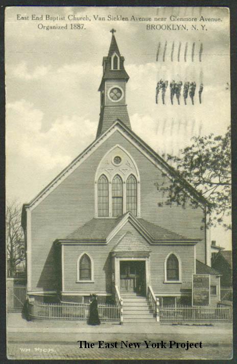
East End Baptist Church,Van Sicklen and Glenmore Maker: Wm. Fick Dated:1910 Status: Own (RG) Organized in 1887, East End first used the Zion Evangelical Church building on Liberty Avenue (pictured on the Liberty Avenue page) until this structure was completed in 1888. Located off the southeast corner of Van Siclen and Glenmore, the image on the right is from 1940. Wes Miller attended East End and gave us some background. |
|
 |
 |
East End Baptist Church, Wedding, 1953 The shot on the right is from the family album of a friend of my mother's. We believe the wedding was at East End, and you can see the "East" in the sign on the right. The church does not look like the clapboard covered structure in the postcard, but the 1930 Percy Loomis Sperr photogrpah on the left shows the church had been renovated. The church is still standing. |
|
 |
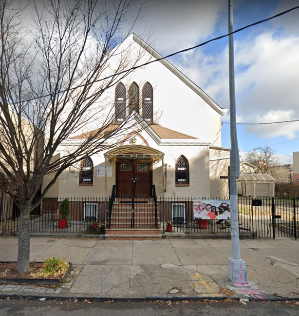 |
Van Siclen Avenue, north across Pitkin Avenue, 1961 and East End Baptist today One more view of the church in this 1961 view, and a 2022 image on the right. Note the steeple is no longer there. Wes Miller helps us with that as well; "...sometime in the early 60s the steeple of the church was struck by lightning, severely damaged, and, eventually, just taken off the structure. I remember the big church bell being kept down in the basement of the church after that." |
|
 |
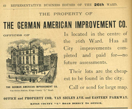 |
Pitkin Avenue, looking west across Van Siclen Avenue, 1961 We now take the camera in the 1961 view above and turn it west. That detailed 4-story brick structure on the left dates to the 1890s. It was the home office of the German American Improvement Company, a real estate development company seen in the ad on the right (Note: "Eastern Parkway" is today's Pitkin Avenue.). The company was instrumental in the early residential development of East New York, including the construction of a modest water supply system. The building still stands today. |
|
 |
 |
Pitkin Ave, By Van Siclen Some more evolution here, courtesy of Neil. This is the north side of Pitkin, between Miller and Van Siclen. Both of Neil's future in-laws lived on this block, which was torn down for low income housing. The entrance to the building in the 2006 photo appears to sit right in the former location of that house. |
|
 |
Not too far away, over on Pitkin and Van Siclen by the 8th Avenue subway station, Mike Bivona sent this pic taken on Easter of 1951. He also provides the IDs; "On the same (northeast) corner was Jack and Lil's candy store and across the street on Pitkin Ave was Brandt's Ice Cream Parlor. The guys names are left to right: Mike (Red) Bivona, Tony Galucci, Tony (Salute) Sturiano, Pete Basile, on bottom: Pete Sturiano, Louie Skita and brother Mike Skita. On top is Leo (no last name)". | ||
 |
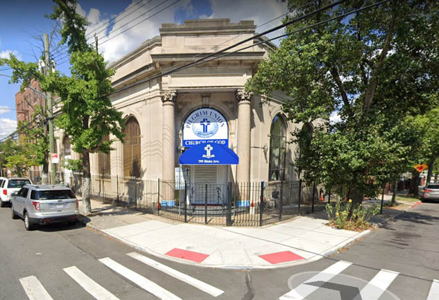 |
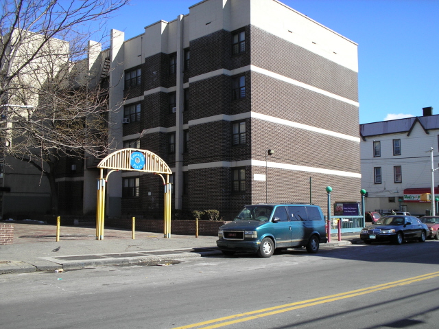
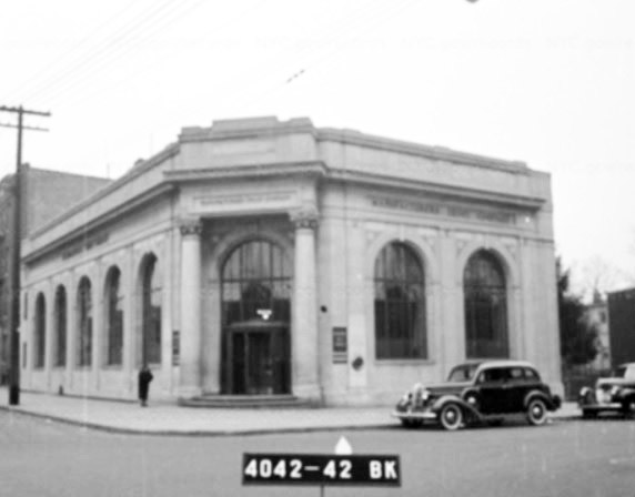
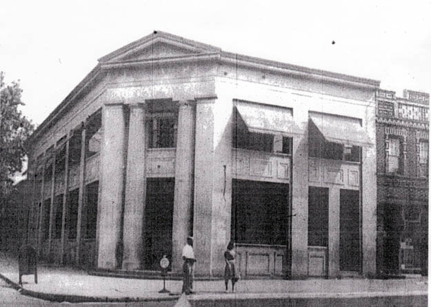
Northeast corner, Blake and Van Siclen The State Bank was constructed in 1922, later acquired by Manufacturers Hanover Trust as seen in the 1940 tax photo on the left. At the time of completion, the granite pillars had not been installed due to a strike by granite workers in Maine. The building was sold to a religious organization in 1977. Pilgrim Union Church of God worships here today. |
|
 |
Van Siclen Avenue, north to Dumont Avenue, 1963 The buildings in this view remain standing today. Fellowship Baptist Church currently occupies the corner building on the right. |
||
 |
 |
George Gershwin JHS 166, Van Siclen and Stanley Avenues, 1959 Completed in 1956, the school accommodated the increased population from the construction of the Linden and Boulevard Houses. The first view is north on Van Siclen to Stanley Avenue. The second view toward the Boulevard Houses is looking east along Stanley from Van Siclen Avenue. |
|
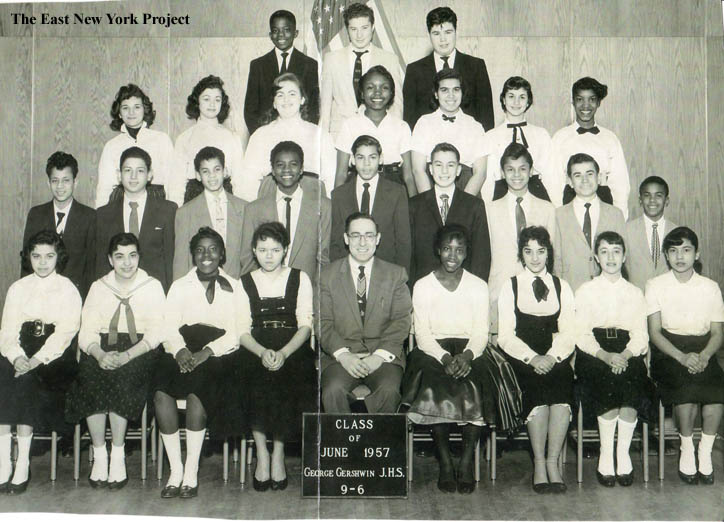 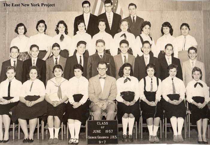 |
George Gershwin JHS 166, Class 9-6, 1957 Thanks to Evelyn Israel for supplying some images from this school George Gershwin JHS 166, Class 9-7, 1957 Evelyn also supplied some names; "Rochelle Schwartz, Fran Lutwin, Janet Rosenberg, Marilyn Rochlin, Harriet Leventhal, Helene Cohen, Barbara Flanzveich, Marsha Levine Martin Efman, Geoffrey Posner, Stanley Friedman, Lenny Smith, Ronald Rind, Kenneth Milkman, Marshall Novack, Barry Goldmuntz Rochelle Cohen, Marsha Gemorah, Adele Leibowitz, Sheila Grundfest, Rachel Galimidi Larry Bernstein, Eric Haber, Thomas Neaman." |
||
 |
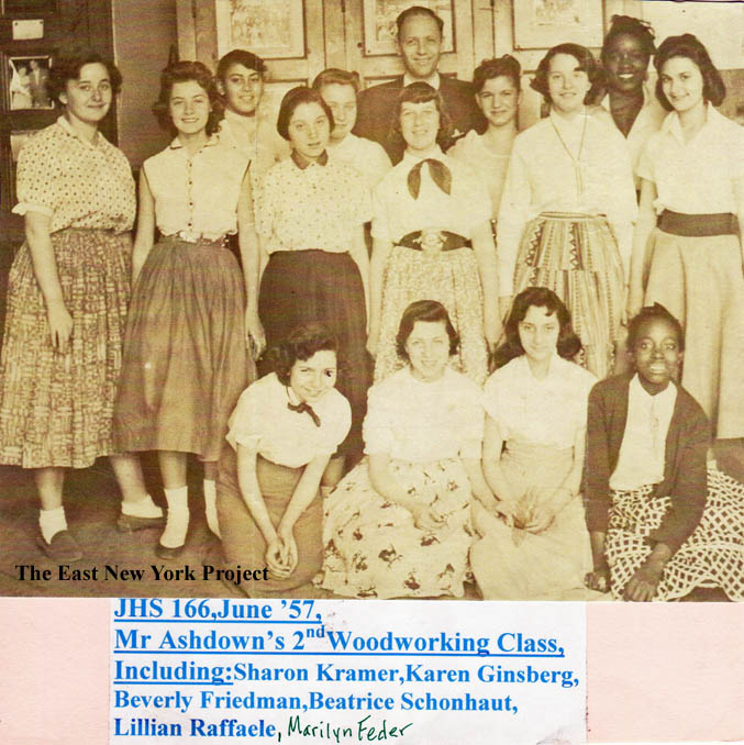 |
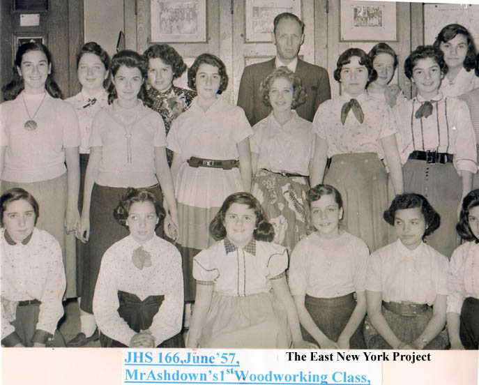
George Gershwin JHS 166, Woodworking Class, 1957 Evelyn also slipped in 2 shots from the 1957 woodworking classes. |
|
| Hendrix Street has its own page, click here | |||
| Schenck Avenue | |||
 |
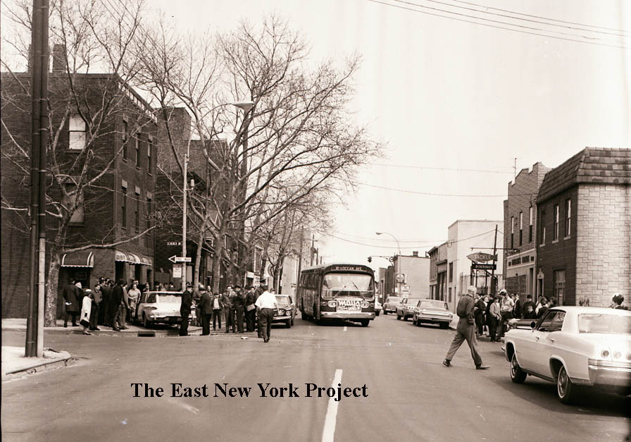 |
Schenck and Liberty Avenues, 1960s We start at the intersection of Schenck and Liberty Avenue. The first view is looking north, toward Atlantic Avenue. The smokestack is from the old Borden's plant. The view on the right is looking east along Liberty from Schenck. Doering's fishing tackle store is visible on the right. |
|
 |
 |
These are closeups from an alternate take of the second view along Liberty Avenue. | |
 |
 |
Liberty and Schenck, 1952 Ironically, this collection included an accident on the same corner in 1952; the bar at the time was the Liberty Tavern and we can see the fishing store on the right. |
|
 |
 |
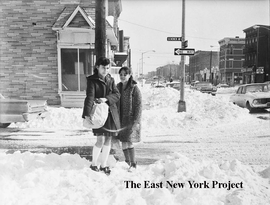
Schenck Avenue, looking east along Pitkin Avenue From our 1967 blizzard series. This one has a nice big street sign but I still had to consult insurance maps and Google maps to confirm the location. As you can see from the update shot, nothing is still standing but there's real improvement. |
|
 |
 |
Schenck and Sutter Avenues, circa 1965 The first view is north up Schenck across Sutter. The closeup is the southwest corner. |
|
 |
 |
Schenck and Sutter Avenues, circa 1965 The first view is east along Sutter; in the second the camera has turned 180 degrees to face west down Sutter from Schenck. One oddity; the sign reading "Stop here on Red Signal". The nearest light is a block away? |
|
 |
433 Schenck Avenue, circa 1921 Ilene Cohen sent in this early shot of her father Samuel Stekolchik and his brothers Carl and Sidney. This block, between Sutter and Blake, was completely cleared in the 1980s. Ilene also sent in her father's 1924 class picture from P.S. 149, which can be found on that page. |
||
 |
Schenck Avenue, looking north to Blake Avenue Also from the 1967 blizzard series. This one is unconfirmed. My suspicion is the one-story structure on the left was once the Blake Theater. It has the look of a small theater, but everything in this section is gone so more research is needed.Harold Moskowitz believes I have this one ID'd correctly; "I agree with your identification. The store on the northwest corner of Blake and Schenck was Taube's Superette in the late 1950's and early 1960's. I went to school with their daughter, Lena. The commercial building on the southwest corner during the same time frame, I believe was a plumbing supply company. I think it was called Blake Plumbing Supply. I remember delivery trucks backing up to the roll down gate delivery area and seeing piles of pipe etc. on the floor inside." |
||
 |
 |
New Lots Reformed Church Dated: 1910 Maker: Wm. Fick Status: Own (RG) Located at New Lots and Schenck, one of the older churches in Brooklyn still standing, dating to 1824. From 'Old Days and Old Ways'; "The timber was cut in the woods of the farmers of the congregation, who not only gave it but cut, hewed and carted it. A part of it had to be sawed, and they dug a ditch for a pit, over which the logs were placed abd sawed by hand, as saw mills were were few and far away in those days. Even the painting was done by the parishioners and the actual cost of the building amounted to $35". The second view was taken by P.L. Sperr in 1934. |
|
 |
 |
New Lots Reformed Church Schoolhouse, 1963 The rear portion of the church schoolhouse dates to the 1870s, the front section was constructed circa 1900. Still standing in the 1963 image, the building and rectory were cleared in 1970 for the replacement seen on the right in a 2022 image. |
|
 |
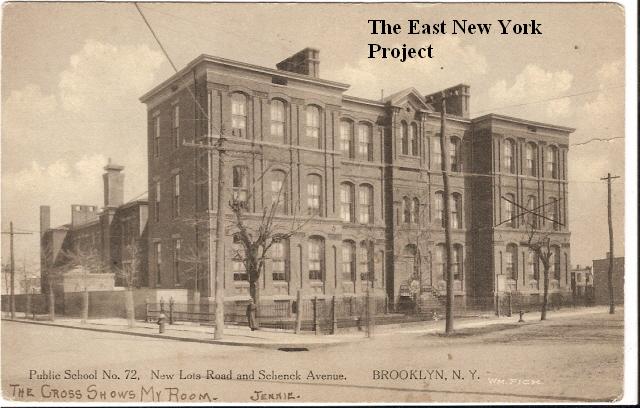 |
P.S. 72, New Lots Road and Schenck Avenue Dated: 1910 Maker: Wm. Fick Status: Own(RG) Across from the church sat the original schoolhouse, built in 1740. This later structure was built in 1810 and eventually moved to 639 Barbey to make way for a brick school. The church's graveyard sat on both sides on New Lots Ave. which means the first two schools sat next to a graveyard. This version of P.S. 72 is the result of numerous additions to the original brick structure. This building is no longer standing, replaced by a branch of the Brooklyn Public Library. Therese Xuereb lived across from this location and recalls the school came down circa 1955. The library was dedicated September 10, 1957. |
|
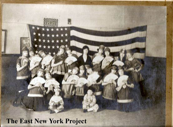 |
P.S. 72, school play, circa1920 Steve Charleston also attended P.S. 72 from 1941 up until its closing and he shared this great early picture of a class play taken around 1920. " My mother, Lillian (Spiegel) Charleston is top row, third from right. Can't ID others. You may not be able to see it in your copy, but the floor is diagonal tongue in groove 3" wide planks identifying the room as "the girls gym". All other rooms had wider planks of lesser quality. The distinctive scroll work in the vent grill was in every room as was the bell. Also, a picture of George Washington and a walnut wall clock with roman numerals. The boys didnt have a gym and no one thought to protest. Imagine that." Steve also shares some great recollections os the school. "When I attended,two elderly ladies, Miss DaVidges and Mrs Hatch taught kindergarden. Lessons included churning butter and hatching frogs eggs. Teachers names that I remember are Mrs. Broome and the only male teacher, Mr. Jennette or Benedict(cant remember) The main building fronting New Lots Ave was built in 1888 according to the inscription over the door. Sometime later additional buildings were added. The basement construction was red brick, similar to the exterior, and basement rooms were dark with roman archways and seperated by large sliding warehouse type doors. ( classmate told me that he was sure Frankenstein lived there) Doors were half glass and the glass was either laminated with wire or taped over because of the war. The school was abandoned by the city in 1944, but not by the school children. The availability of a schoolyard with basketball courts and a large building begging to be explored in minute detail without adult supervision was too much of a temptation." |
||
 |
P.S. 72, May 1944 This news photo was taken on May 8th 1944, after the city announced it would close the school. Identified in the picture are Jules Saks, Donald Weinstein, and Isabel Rosati. |
||
 |
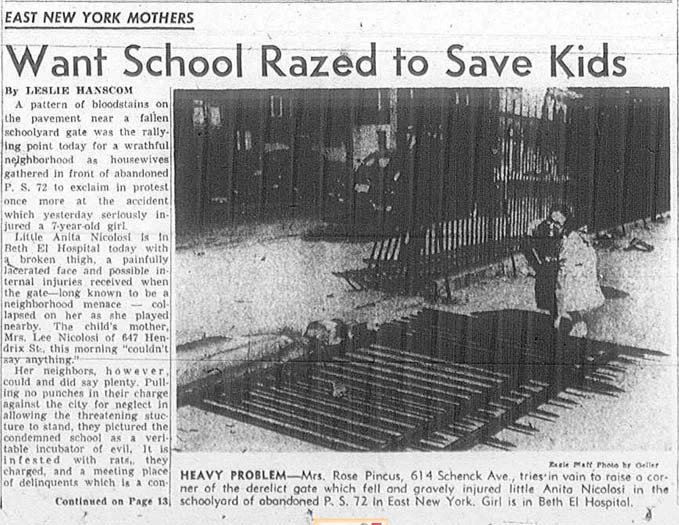 |
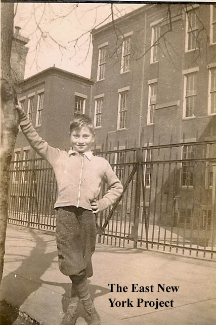
P.S. 72, New Lots Avenue I was able to piece together some of the missing history of this school. On the left, Howard Rubin sent in this image of himself by the school in 1943. He recalls being transfered to P.S. 190 in 1944. After a fire in 1944 revealed the dangers of the old building, the Board of Education quickly closed the school amidst local protests. (Which means Howard was part of the last group to attend P.S. 72!) The building remained vacant and unmaintained, and this Eagle article in 1951 highlighted the dangers of the decaying property. |
|
| Barbey and Jerome Streets | |||
 |
 |
2313, 2316 Pitkin Avenue Located between Jerome and Barbey, Rod Maggio has amazed me with a recall of names and addresses of the neighborhood. Rod notes the Tony (Ia)Danza was born at 2297 Pitkin, several doors down. On the left is Leo "The Limp" Piccola who lived on the 3rd floor and Rod himself in 1951 (Rod noted he slept right behind that window). On the right, from 1953: "Don 'Dunna"' Lucera, Atlantic Ave above Fish Store (Cleve-Elton) lot became Benny Vitucci Sr pre-owned cars......Pete 'Hooknose' Chiapone...330 Jerome St.....Vito 'Willie' Capitelli 338 Warwick St." |
|
 |
 |
Pitkin Avenue, east to Jerome Street It's a shame Rod Maggio has passed, because Brian Merlis recently sent over this image from 1948 and Rod's house at 2313 Pitkin is visible, one in from the left. He probably could have ID'd the woman standing in front. The building on the left, 2311 Pitkin, is still standing as seen in the 2015 image. |
|
 |
Jerome Street, 1949 This great shot from Rod dates to his sister's confirmation in 1949. The view is north towards Atlantic in front of the Convent. That's his sister Angela, Ida (mom) Maggio, Carol "Errico" Maggio, Rod, Joseph (dad) Maggio, Angela & Frank Lualdi (noni & grandpa). Rod recalls; "Sister Helen, didn't actually care for or like Italian American Public School kids in her Religious Instruction Classes Wednesdays 2 to 3:30, Sundays after 9 am Mass, we were "marched" out the side door, into the school building until 11:30". **note** "The building in foreground above my head ,(s/east corner Jerome-Atlantic) has been gone for some time now, the former site was Jerome Bar or Cafe` became Safeway Gas, Saeway, Merit, then Hess (presently) gas station " > Mike Suchocki adds; "Across the street from the Church in the wooden house lived a very famous --Daily News Photographer --Paul Gallagher . He always had one of his action photos published on the middle page of the paper almost everyday in the 40's & 50's I remember his son Paul Jr. who went to Power Memorial and was a member of the St. Michael's Marching Band." |
||
 |
Jerome St., 1948 Rod Maggio supplies a nice wedding day picture taken June 27, 1948 off of Pitkin Ave and Jerome St. Rod provides the IDs; " Maid of Honor, Antoinette Errico (grooms sister) Joe Maggio, Carol Maggio, Flower Girl, Angela Maggio, limo driver Willie Terlizzi (grooms cousin) Backround Limo is 37 or 38 LaSalle (Division of Cadillac) 1940 was last year of production for LaSalle." |
||
 |
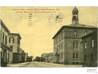 |
St. Michael's Church Dated:1910 Maker: P. Miller Status: Own (BG) There is now a page dedicated to St. Michael's church and School, located here These two postcards show the original church and the school around 1910. |
|
 |
Synagogue Demetrius Pestun is helping us backfill the missing synagogues from the site. Pictured is the Sons of Judah Temple, built I believe around 1930. Located on Sutter Ave. between Barbey and Jerome, it is now Messiah Baptist Church. Rod Maggio believes Rev. Elijah Pope bought or rented the building around 1964- the same time he bought his building at 2313 Pitkin, and quickly drove out all the long term tenants. |
||
 |
 |
Synagogues Demetrius also sent in this one of Talmud Torah, located at Ashford and Sutter. I have yet to uncover details of its history during this time period, but I believe the building was originally constructed for the Bank of the United States in 1928. JoAnn Montgomery tracked down the 1941 tax photo for us, but it did not reveal any details. |
|
 |
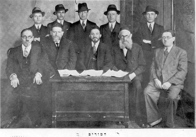 |
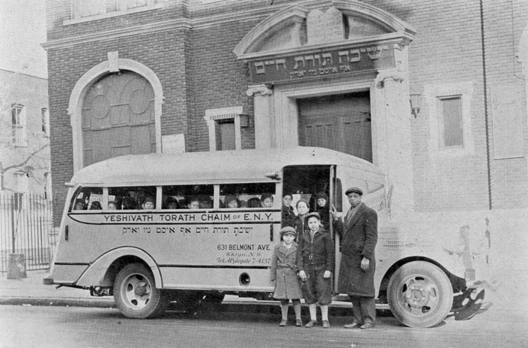
Yeshiva Toras Chaim, 1936 A big thank you to Zevi Isseroff who supplied a history and several pictures for this Yeshiva. "Yeshiva Toras Chaim was founded in 1927 in East New York by Rabbi Isaac Shmidman. The Yeshiva of South Shore was established in 1956 by Rabbi Binyomin Kamenetzky. In 1963 the two yeshivas merged and moved into its new campus, later named the Manfred and Jamie Lehmann Campus on 1170 William Street, Hewlett, NY....on the main floor of the school was the synagogue, its capacity was around 350 seats. I do not remember the synagogue having daily services. It probably had services only on sabbath and Jewish holidays. I believe that Rabbi Shmidman also served as the synagogue Rabbi." On the right is a 1936 image of the Rabbinical staff, with Rabbi Schmidman seated, center, at the table.Historical note: David Diamond attended the Yeshiva in ENY and graduated in 1964; the final year of operation there was 1965. |
|
 |
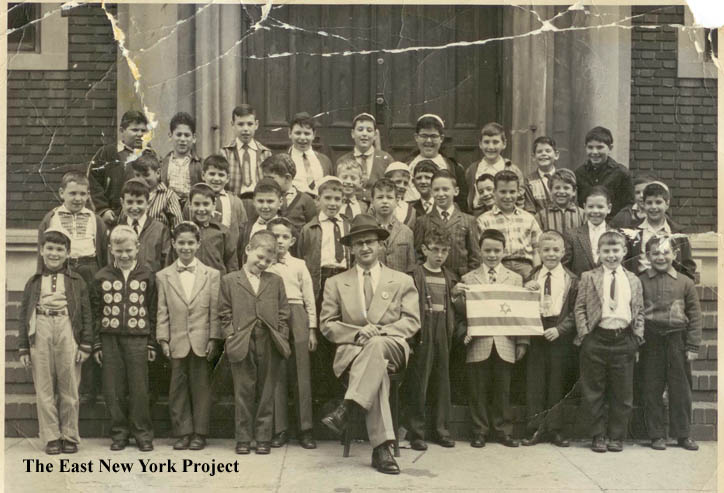 |
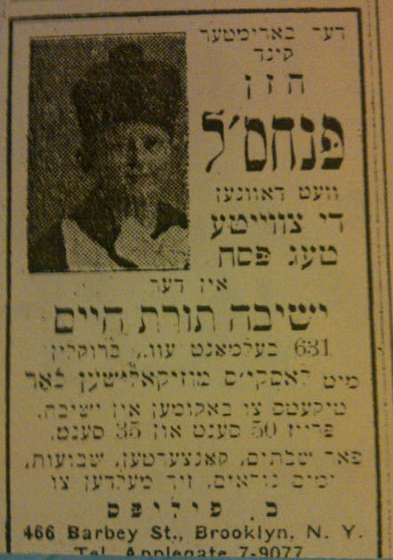
Yeshiva Toras Chaim On the left, Zevi supplied this advertisement; " My wife's uncle, Pincus Phillips, was a child prodigy super-star cantor when he was 11 years of age.... He was sought after by many congregations and led many services. I've attached an advertisement from a Yiddish newspaper in 1936-at the Congregation in the Yeshiva at 631 Belmont, where the wonder child Pincus Phillips was to conduct services for the 2nd day of Passover. Tickets were 50 cents and 35 cents." On the right, a class picture from 1960. Rabbi Blau is seated in front. Zevi recalls; "My most vivid memory was in 1963, when on the holiest day in the Jewish Calendar, Yom Kippur night, I was attending services on a synagogue on Ashford street between Blake and Sutter. A few members from the Yeshiva congregation walked over to our synagogue and asked for some volunteers--they did not have a quorum of ten men for the services. We realized that Jewish life in East New York was rapidly coming to an end." |
|
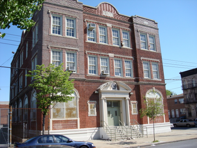 |
Yeshiva Toras Chaim, today A recent photo, the building is now owned by the Board of Education and is the Community School for Comprehensive Education. Compare this to the 1936 image and you can see all the ornamentation connecting it to the Yeshiva is gone. Rod Maggio recalls back in the 1950s they used to turn the lights on for Yeshiva on Friday nights, and sometimes crashed the weddings held in the basement ballroom! |
||
 |
Ted Maciag sent in this great 1928 picture taken in front of 432 Warwick Street, which is just south of Pitkin Ave. The El can be seen on the right. We need a car buff to ID the great car in the shot. | ||
 |
 |
Can you guess where this is? Lou Schreiner sent in these shots from 1947. "On the Southwest corner of Linden Blvd. and Pennsylvania Avenues there was Fishman's Dairy, open field with cows, chickens,barn,goats,etc. Continuing south lived several families, then a junk yard, then all the marshes that were eventually filled in where Starret City, the Belt Pkwy and so forth are today. Also there were several riding acadamies heading east on Linden from Pennsylvania." |
|
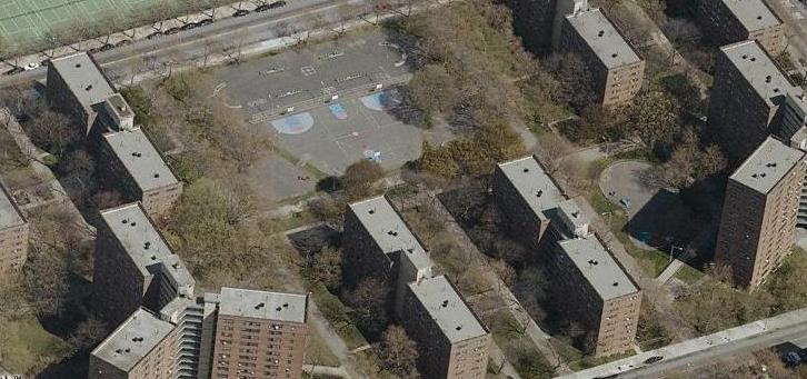 |
Linden Projects There is actually another website titled ENY Projects, devoted to the projects south of Linden Boulevard. The Boulevard Houses were the first large scale housing project down there, built in 1951. Their website has some old pictures and stories from those who lived there. |
||
 |
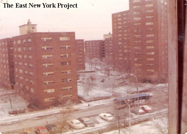 |
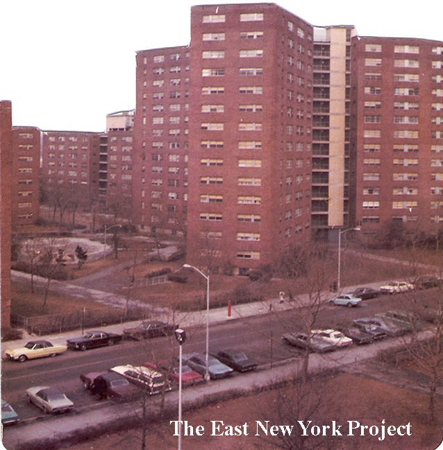
Linden Houses Al Durant took these shots of the Linden Houses from his apartment in the early 1970s. The Linden Houses were completed in 1958, and Al's family moved in about 1958 from Brownsville. (His uncle's company, Durant and Sons Moving, was one of the early successful black-owned businesses in the area). Bill Weiss, who corrected me on the completion year, also moved in those first years and noted that the project was constructed north to south, but the streets were paved south to north, so "we were tracking mud into our apartment for a long time." The prior use of this land was a bit interesting, see below. Al also adds a story about the land used for Starrett City. |
|
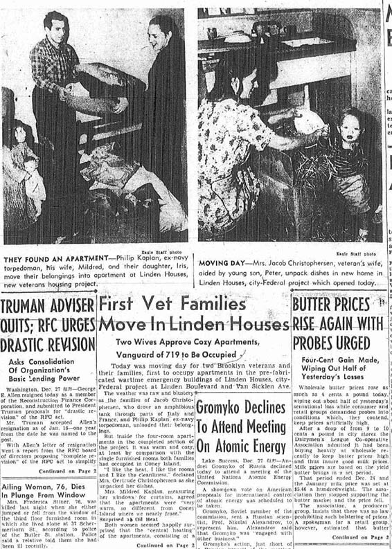 |
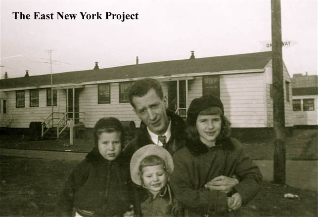
Linden Veterans Houses After the war, the city was scrambling for places to house returning veterans. Vacant land between Linden Boulevard and Cozine Avenue (north to south) and New Jersey and Miller Avenues (west to east) was used to re-construct transplanted barracks. I heard from Alison Kaplan Dillworth who told me her parents were the first to move in, and she wasn't exaggerating. That's her folks on the front page of the Brooklyn Daily Eagle and the New York Evening Post (below) on December 27, 1946. Alison adds; "My mother decorated the place pretty nice with wallpaper and linoleum, our bedroom had mother goose characters on the linoleum floor and on the walls. My father had made a closed in porch on the back of the house and a shed. We had two bedrooms, a living room and eat in kitchen, before we moved, there were 3 of us in the one bedroom, my 2 sisters and me. We had a TV when they came along, too. We had a nice yard, it was a pretty good size. We were on a corner property and I remember a big open field across the street. I recall finding a jaw of a cow there, probably used to be grazing field for the dairy nearby...Sunnydale I believe on Stanley Avenue. We lived on 5th Walk and I found Dr. Bursen's address as Linden Houses 18 D Brandford Drive. I remember my sister took dance lessons in the projects which were a short walk from where we lived." |
||
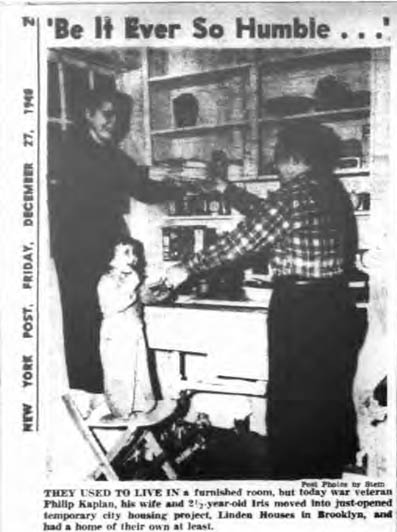 |
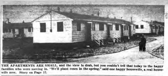 |
Linden Veterans Houses The New York Post articles. I found numerous articles recounting how poorly the structures fares during inclement weather. This "temporary" solution lasted until 1954 when the most of that land was cleared for the Linden Houses. |
|
 |
 |
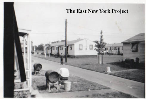
Linden Veterans Houses Sam Leftow also lived on 5th walk, and sent over some pics of the "Linden Barracks" as he knew them. Sam points out the oil drums in front of each unit, recalling that used to be his 'horsey' as a kid. We assume these contained heating oil, Sam noted they had a spigot so we also assumed there was no direct connection to a furnace. |
|